Western North Carolina Location Over The Blue Ridge
Description
This section is from "Scientific American Supplement". Also available from Amazon: Scientific American Reference Book.
Western North Carolina Location Over The Blue Ridge
Location Over The Blue Ridge
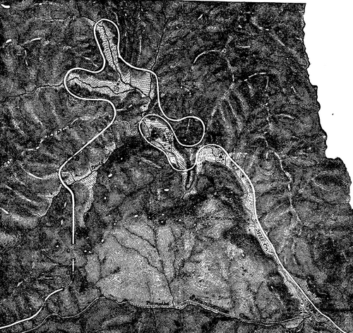
WESTERN NORTH CAROLINA RAILROAD.
The interesting piece of railroad location illustrated in this issue is on the mountain section of the Western North Carolina Railroad. This section crosses the Blue Ridge Mountains 18 miles east of Asheville, at a point known as Swannanoa Gap, 2,660 feet above tide water. The part of the road shown on the accompanying cut is 10 miles in length and has an elevation of 1,190 feet; to overcome the actual distance by the old State pike was somewhat over 3 miles. The maximum curvature as first located was 10°, but for economy of time as well as money this was exceeded in a few instances as the work progressed, but is now being by degrees reduced. The maximum grades on tangents are 116 feet per mile; on curves the grade is equated one-tenth to a degree. The masonry is of the most substantial kind, granite viaducts and arch culverts. The numbers and lengths of tunnels as indicated by letters on cut are as follows:
| Ft. in all of these. | |||||
| A. | Point Tunnel. | 216 | ft. | long.1 | |
| B. | Jarrett's Tunnel. | 125 | " | " | |
| C. | Lick Log Tunnel. | 562 | " | " | |
| D. | McElroy Tunnel. | 89 | " | " | |
| E. | High Ridge Tunnel. | 415 | " | " | |
| F. | Burgin Tunnel. | 202 | " | " | |
| G. | Swannanoa Tunnel. | 1,800 | " | " | |
The work was done by the State of North Carolina with convict labor, under the direction of Mr. Jas. A. Wilson, as president and chief engineer, but was sold by the State to the Richmond & Danville system. - Railroad Gazette.
[1]For the sake of economy of space, our cut omits the Point and Swannanoa tunnels (the latter is the summit tunnel), but covers all of the location which is of interest to engineers, the remainder at the Swannanoa end being almost "on tangent" to and through the summit.
Continue to:
My Books

