Niagara
Description
This section is from "The American Cyclopaedia", by George Ripley And Charles A. Dana. Also available from Amazon: The New American Cyclopædia. 16 volumes complete..
Niagara
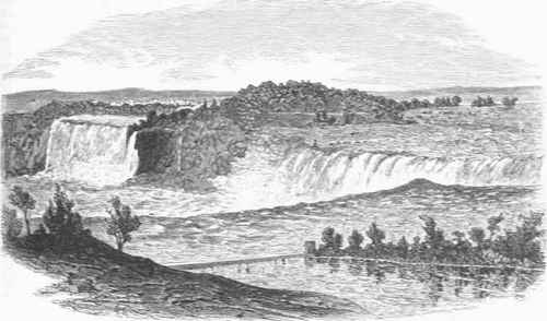
Niagara, a river of the United States and Canada, flowing N. 33 m. from Lake Erie to Lake Ontario, between the state of New York and the province of Ontario, and having in its course the most celebrated falls in the world, it is the channel by which all the waters of the four great upper lakes flow toward the gulf of St. Lawrence, and has a total descent of 333 ft., leaving Lake Ontario still 231 ft. above the sea. The interruption to navigation occasioned by the rapid descent of the Niagara river is overcome on the Canadian side by the Welland canal; and on the American side the communication between tide water and the upper lakes was first effected by the Erie canal. From the N. E. extremity of Lake Erie the Niagara river flows in a northerly direction with a swift current for the first 2 m.. and then more gently with a widening current. which divides as a portion passes on each side of. Grand island. As these unite below the island. the stream spreads out to 2 or 3 m. in width. and appears like a quiet lake studded with small low islands. About 16 m. from Lake Erie the current grows narrow and begins to descend with great velocity. This is the:om-mencement of the rapids, whieh continue for about a mile, the waters accomplishing in this distance a fall of 52 ft.
The rapids terminate below in a great cataract the descent of is 164 ft. on the American sideand 150on the Canadian. At this point the river, making a curve from W. to N., spreads out to an extreme: width of about 4,750 ft Goat island, which extends down to the brink of the cataract. Occupies about one fourth of this space, leaving the river on the American side about 1,100 ft. wide, and on the Canadian side about double this width. The line along the verge of the Canadian fall is much longer than the breadth of this portion of the river, by reason of its horse-shoe form. the curve extending up the central part of the current. The waters sweeping down the rapids form a grand curve as they fall clear of the rocky wall into the deep pool at the base. The space between this sheet of water and the wall widens near the bottom. the strata being there of a lose shaly character and conequently hollwed out by the continual action of the spray. A cave (called the Cave of the Winds) is thus formed behind the fall, into which on the Canadian side persons can enter and pass by a rough and slipeery path toward Goat island.
Among the great cataracts of the globe that of Niagara stands preeminent for the enormous volume of water that is carried over so high a preci[ice. There are many cataracts which descend from greater heights but the sublimity of Niagara is in the vast power displayed by a mighty current descending down the long rapids, and finally plunging in one unbroken sheet into the deep abyss below. In the deep chasm below the fall the current, contracted in width to less than 1,000 ft., is tossed tumultuously about, abd forms great whirpools and eddies as it is borne along its rapidly descending bed. Dangerous as it appears, the river is here crossed by small row boats. On each side of the gorge the walls rise almost perpendiculary from the talus of fragments piled up along their base, and access to and from the summit is had only by means of stairways constructed at several points. For 7m. below the falls the narrow george continues. varying in width from 200 to 400 yards.
Falls of Niagara.
The river then emerges at Lewiston into lower district, having decended 1041 ft, from the foot of the cataract. Several objects of interest are met with in this portion of its course.
Abour 2m. below the falls is a suspension bridge, thrown across the george at the height of 245 fr, above the water, and supported by towers upon each bank, the centres of which are 821 ft, apart. The current is here about 350 ft, wide. The bridge was constructed in 1855 by Mr. Roebling for the passage of railway trains, and 18 ft. below the railway it also sustains a carriage and foor track. From this brodge a fine view is had of the falls. A suspension bridge about 1/8m, below the falls was finished in 1869 at a cost of $175,000: it is 1,190 ft, from cliff to cliff, and 1,268 from tower to tower, and 190 ft, above the river.
Three miles below the falls the river, bending toward the Canadian side and contracted to a width of about 220 ft, rushes violently into a deep depression in the steep cliff on that side, from which it emerges, turning back almost at a right angle into the American side. This depression ((resents the appearance of having been hollowed out by a great eddy or whirl of the waters, and is known as "the whirlpool." It seems to be a portion of the bed of an ancient channel, now filled with diluvium. The surface of the country, which at the foot of Lake Erie is low, scarcely rising above the level of its waters, gradually becomes more elevated toward the north, till near Lewiston it is 38 ft. higher than Lake Erie. The course of the Niagara river is thus in the direction of the ascent of this inclined plane, and must originally have been induced by a depression in the surface. Beyond this there occurs a sudden descent toward Lake Ontario of 250 ft., down to the plateau upon which stands on the American side of the river the village of Lewiston, and on the Canadian that of Queenston. The high land forms a bold terrace looking out upon Lake Ontario, from which it is 7 m. distant, and from its foot the surface descends so gently to the lake that the fall, amounting to 120 ft., is hardly perceptible.
The fall made by the river in this lowest portion of its course is only 4 ft., not impeding navigation. - The gorge through which the Niagara river flows below the falls, amounting at the terrace to about 300 ft. in depth, bears evidence of having been excavated by the river itself. In the short period, hardly reaching back into the last century, during which observations other than those of passing travellers have been made and preserved, changes have taken place by the falling down of masses of rock, the effect of which has been to cause a slight recession of the cataract, and extend the gorge to the same amount upward toward Lake Erie. Thus in 1818 great fragments descended at the American fall, in 1828 at the Horse-shoe fall, and since 1855 several others, which have materially changed the aspect of the falls. Table rock, once a striking feature, has wholly disappeared. Previous to the careful trigonometrical survey made in 1842 under the direction of Prof. James Hall, for the state geological survey, no marks nor monuments had been fixed, by which the rate of recession could be ascertained.
The results of this survey, with the map of the falls, are presented in the state geological report of Prof. Hall. In this report is a facsimile of a view of the falls by Father Hennepin, made in 1678. This sketch and the accompanying description present a striking feature in the falls which has now entirely disappeared; this is a third fall from the Canadian side toward the east, facing the line of the main fall, and caused by a great rock that turned the divided current in this direction. In 1750 the falls were visited by Kalm, a Swedish naturalist, whose description and view were published in the "Gentleman's Magazine" in 1751; he alludes to the rock having fallen down a few years previous, and indicates the spot in his sketch. From such evidences it is certain that changes have been and are taking place, which have excavated the great gorge, and will carry it further up toward Lake Erie. But the rate at which these changes take place is not uniform. For several successive years there will be no apparent change; and then, the soft underlying strata having been gradually worn away, great masses of the upper and harder ones fall down, causing a very noticeable change in a very brief time.
Taking long periods, the estimate of Lyell that the retrocession of the falls has been about a foot a year appears to be approximately correct. From the variable nature of the strata over which the river flows, the circumstances that affect the rapidity of the cutting action differ all along its course. At the present site of the falls sheets of a hard limestone rock, of the formation known as the Niagara limestone, cover the surface of the country, and form the edge of the cataract to the depth of between 80 and 90 ft. Under this, extending to the foot of the fall, are the shaly layers of the same formation. All these strata slope downward against the current of the river at the rate of about 25 ft. in a mile; and in the rapids above the fall the uppermost layers of the Niagara limestone succeed, one stratum above another, till about 50 ft. more is added to the thickness of the formation, when all disappear beneath the outcropping edges of the next series above, which is that of the shales and marls of the Onondaga salt group.
In the other direction, toward Lake Ontario, these strata gradually rise to higher levels, till along the great terrace the capping is of the lower 20 ft. of the Niagara limestone, below which the shaly strata form the next 80 ft. of the steep slope; and next appears a succession of calcareous layers, shales, and sandstones, belonging successively to the Clinton and Medina formations. Through these piles of strata the river has worked its way back, receding probably most rapidly where, as in its present position, the lower portion of the cutting was composed of soft beds, which being hollowed out let down the harder strata above; and less rapidly where the strata near the base were hard sandstones, such as occur in some of the lower groups. The effect of continued recession must be to grad-uallv diminish the height of the falls, both by the rising of the bed of the river at their base and by the slope of the massive limestone to a lower level. The thin-bedded limestones above being swept off, the succeeding shales and marls of the Onondaga salt group must immediately follow, and the falls may then become almost stationary, when their base is at the base of the massive sandstone and their upper line is as now over its upper edge.
This, as shown by Prof. Hall, is likely to be the case after a further recession of about 2 m., and the height of the fall must then be reduced to about 80 ft. On both sides of the river, and especially on Groat island, are beds of sand, gravel, and clay, evidently deposited by running water, containing great numbers of fresh-water shells of the same genera and species as those now living in the river and deposited along its banks, such as the unio, cyclas, limnea, planorbis, val-mta, and melania. These strata reach to the height of 40 ft. above the top of the fall, and ire met with in occasional patches at the same level near the edges of the precipice for 4 m. below. They show that the waters must have spread over a wide area and been kept back by some high barrier between the whirlpool and Lewiston. The bowlder or drift formation underlies the fluviatile strata, thus referring their formation to the latest geological period. - The most complete accounts of Niagara falls are contained in the report of Prof. Hall, and in vol. i. of "Travels in North America," by Sir Charles Lyell. See also "Niagara, its History, Geology, and Poetry," by George W. Holley (New York, 1871).
Continue to:
My Books

