How To Establish A True Meridian
Description
This section is from "Scientific American Supplement". Also available from Amazon: Scientific American Reference Book.
How To Establish A True Meridian
[Footnote: A paper read before the Engineers' Club of Philadelphia.]
By PROFESSOR L. M. HAUPT.
Introductory
The discovery of the magnetic needle was a boon to mankind, and has been of inestimable service in guiding the mariner through trackless waters, and the explorer over desert wastes. In these, its legitimate uses, the needle has not a rival, but all efforts to apply it to the accurate determination of permanent boundary lines have proven very unsatisfactory, and have given rise to much litigation, acerbity, and even death.
For these and other cogent reasons, strenuous efforts are being made to dispense, so far as practicable, with the use of the magnetic needle in surveying, and to substitute therefor the more accurate method of traversing from a true meridian. This method, however, involves a greater degree of preparation and higher qualifications than are generally possessed, and unless the matter can be so simplified as to be readily understood, it is unreasonable to expect its general application in practice.
Much has been written upon the various methods of determining, the true meridian, but it is so intimately related to the determination of latitude and time, and these latter in turn upon the fixing of a true meridian, that the novice can find neither beginning nor end. When to these difficulties are added the corrections for parallax, refraction, instrumental errors, personal equation, and the determination of the probable error, he is hopelessly confused, and when he learns that time may be sidereal, mean solar, local, Greenwich, or Washington, and he is referred to an ephemeris and table of logarithms for data, he becomes lost in "confusion worse confounded," and gives up in despair, settling down to the conviction that the simple method of compass surveying is the best after all, even if not the most accurate.
Having received numerous requests for information upon the subject, I have thought it expedient to endeavor to prepare a description of the method of determining the true meridian which should be sufficiently clear and practical to be generally understood by those desiring to make use of such information.
This will involve an elementary treatment of the subject, beginning with the
Definitions
The celestial sphere is that imaginary surface upon which all celestial objects are projected. Its radius is infinite.
The earth's axis is the imaginary line about which it revolves.
The poles are the points in which the axis pierces the surface of the earth, or of the celestial sphere.
A meridian is a great circle of the earth cut out by a plane passing through the axis. All meridians are therefore north and south lines passing through the poles.
From these definitions it follows that if there were a star exactly at the pole it would only be necessary to set up an instrument and take a bearing to it for the meridian. Such not being the case, however, we are obliged to take some one of the near circumpolar stars as our object, and correct the observation according to its angular distance from the meridian at the time of observation.
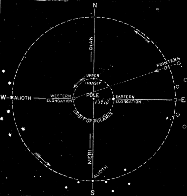
For convenience, the bright star known as Ursae Minoris or Polaris, is generally selected. This star apparently revolves about the north pole, in an orbit whose mean radius is 1° 19' 13",[1] making the revolution in 23 hours 56 minutes.
[Footnote 1: This is the codeclination as given in the Nautical Almanac. The mean value decreases by about 20 seconds each year.]
During this time it must therefore cross the meridian twice, once above the pole and once below; the former is called the upper, and the latter the lower meridian transit or culmination. It must also pass through the points farthest east and west from the meridian. The former is called the eastern elongation, the latter the western.
An observation may he made upon Polaris at any of these four points, or at any other point of its orbit, but this latter case becomes too complicated for ordinary practice, and is therefore not considered.
If the observation were made upon the star at the time of its upper or lower culmination, it would give the true meridian at once, but this involves a knowledge of the true local time of transit, or the longitude of the place of observation, which is generally an unknown quantity; and moreover, as the star is then moving east or west, or at right angles to the place of the meridian, at the rate of 15° of arc in about one hour, an error of so slight a quantity as only four seconds of time would introduce an error of one minute of arc. If the observation be made, however, upon either elongation, when the star is moving up or down, that is, in the direction of the vertical wire of the instrument, the error of observation in the angle between it and the pole will be inappreciable. This is, therefore, the best position upon which to make the observation, as the precise time of the elongation need not be given. It can be determined with sufficient accuracy by a glance at the relative positions of the star Alioth, in the handle of the Dipper, and Polaris (see Fig. 1). When the line joining these two stars is horizontal or nearly so, and Alioth is to the west of Polaris, the latter is at its eastern elongation, and vice versa, thus:
But since the star at either elongation is off the meridian, it will be necessary to determine the angle at the place of observation to be turned off on the instrument to bring it into the meridian. This angle, called the azimuth of the pole star, varies with the latitude of the observer, as will appear from Fig 2, and hence its value must be computed for different latitudes, and the surveyor must know his latitude before he can apply it. Let N be the north pole of the celestial sphere; S, the position of Polaris at its eastern elongation; then N S=1° 19' 13", a constant quantity. The azimuth of Polaris at the latitude 40° north is represented by the angle N O S, and that at 60° north, by the angle N O' S, which is greater, being an exterior angle of the triangle, O S O. From this we see that the azimuth varies at the latitude.
We have first, then, to find the latitude of the place of observation.
Of the several methods for doing this, we shall select the simplest, preceding it by a few definitions.
A normal line is the one joining the point directly overhead, called the zenith, with the one under foot called the nadir.
The celestial horizon is the intersection of the celestial sphere by a plane passing through the center of the earth and perpendicular to the normal.
A vertical circle is one whose plane is perpendicular to the horizon, hence all such circles must pass through the normal and have the zenith and nadir points for their poles. The altitude of a celestial object is its distance above the horizon measured on the arc of a vertical circle. As the distance from the horizon to the zenith is 90°, the difference, or complement of the altitude, is called the zenith distance, or co-altitude.
The azimuth of an object is the angle between the vertical plane through the object and the plane of the meridian, measured on the horizon, and usually read from the south point, as 0°, through west, at 90, north 180°, etc., closing on south at 0° or 360°.
These two co-ordinates, the altitude and azimuth, will determine the position of any object with reference to the observer's place. The latter's position is usually given by his latitude and longitude referred to the equator and some standard meridian as co-ordinates.
The latitude being the angular distance north or south of the equator, and the longitude east or west of the assumed meridian.
We are now prepared to prove that the altitude of the pole is equal to the latitude of the place of observation.
Let H P Z Q¹, etc., Fig. 2, represent a meridian section of the sphere, in which P is the north pole and Z the place of observation, then H H¹ will be the horizon, Q Q¹ the equator, H P will be the altitude of P, and Q¹ Z the latitude of Z. These two arcs are equal, for H C Z = P C Q¹ = 90°, and if from these equal quadrants the common angle P C Z be subtracted, the remainders H C P and Z C Q¹, will be equal.
To determine the altitude of the pole, or, in other words, the latitude of the place.
Observe the altitude of the pole star when on the meridian, either above or below the pole, and from this observed altitude corrected for refraction, subtract the distance of the star from the pole, or its polar distance, if it was an upper transit, or add it if a lower. The result will be the required latitude with sufficient accuracy for ordinary purposes.
The time of the star's being on the meridian can be determined with sufficient accuracy by a mere inspection of the heavens. The refraction is always negative, and may be taken from the table appended by looking up the amount set opposite the observed altitude. Thus, if the observer's altitude should be 40° 39' the nearest refraction 01' 07", should be subtracted from 40° 37' 00", leaving 40° 37' 53" for the latitude.
How To Establish A True Meridian
In looking over the excellent article of Professor S. M. Haupt, in the SCIENTIFIC AMERICAN SUPPLEMENT, No. 360, on the subject of finding the meridian, I discovered that one important step is not given, which, might prove an embarrassment to a new beginner.
In the fourth paragraph, in the third column of page 5,748, he says: "Having now found the altitude, correct it for refraction, ... and the result will be the latitude."
It will be observed that this result is only the true altitude of the star. The latitude is found by further increasing or diminishing this altitude by the polar distance of the star.
This paper will be of great value to engineers and surveyors, for the elementary works on surveying have not treated the subject clearly.
H. C. PEARSONS, C.E.
Ferrysburg, Mich.
Continue to:
My Books

