Snow, Ice, The Sea, Lakes, Animals And Plants as Destructive Processes. Part 3
Description
This section is from the book "An Introduction To Geology", by William B. Scott. Also available from Amazon: An Introduction to Geology.
Snow, Ice, The Sea, Lakes, Animals And Plants as Destructive Processes. Part 3
This is a type of especial interest and significance to the geologist, because of the light which it throws upon the often mysterious operations of the ice-sheets which once covered large portions of North America and Europe.
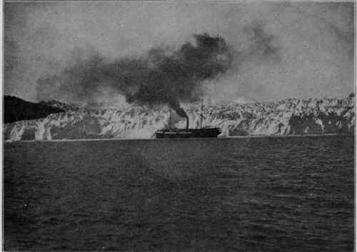
Fig. 66. - The Columbia Glacier, Alaska. (U. S. G. S).
Glacier Erosion is highly characteristic, and enables us to detect the former extension of ice-streams which have greatly shrunken and their former presence in regions whence they have long vanished. The erosive capabilities of moving ice have been and still are the subject of much dispute, but the researches of the last ten or fifteen years in many parts of the world have brought together a great body of evidence which strongly supports the view that glaciers, under favouring conditions, are extremely efficient and powerful agents of erosion. Just as in the case of water, the destructive power of ice depends upon the velocity with which it moves and the pressure exerted on its bed, so that a glacier may erode actively at one part of its course, and little or not at all at another. It is not surprising, therefore, that advancing glaciers have been observed to override loose masses of gravel without moving them.
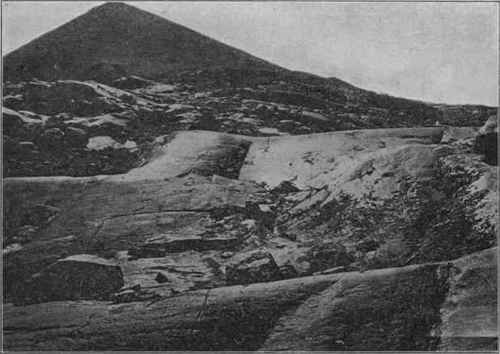
Fig. 67. - Glaciated surface, Sierra Nevada, Cal. The angular recesses indicate places where blocks have been removed by plucking. (U. S. G. S).
When acting effectively, newly formed glaciers remove the soil, talus, and other loose materials from the surface, which thus, in the first instance, is rendered more irregular than before, because of the varying depths to which the effects of weathering penetrate (see p. 101). Bare rocks are eroded by a double process: (1) The joint-blocks are torn away (plucking) by the advancing ice, an operation which is much facilitated by the continual liquefaction and regelation of the ice at the bottom of the glacier, owing to changes of pressure. As has been already remarked, the temperature of the ice within and at the bottom of the glacier is near the melting-point for the pressure. Thus, slight changes of pressure, due to the motion of the glacier and inequalities of the bed, cause the ice now to melt and again to solidify, and in this manner the joint-blocks of the bed-rock are loosened. (2) The bottom of the glacier is a mass of ice mingled with rocks, pebbles, boulders, sand, and debris of all sizes, and by their means the bed-rock is worn down, smoothed, polished, and scored with parallel marks, in a fashion which forms the unmistakable autograph of the glacier.
The rock fragments, firmly held by the immense weight of the ice, are slowly pushed over the rocky bed and cut grooves corresponding to the size of the fragments, from hair-like scratches to deep troughs. The scorings are, of course, in the direction of the movement and keep parallel often for considerable distances. The smaller particles act as a polishing powder and smooth the bed, and, if the bed-rock is sufficiently hard, it receives a high polish. Hummocks of rock, over which the ice has flowed, are worn and rounded into the form called "roches moutonnees," with the upstream side gently sloping and polished, but with the downstream side abrupt and often rough.
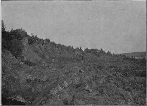
Fig. 68. - Steeply inclined strata, with edges roughened by glacial plucking, overlaid by glacial drift, Iron Mt., Mich. (U. S. G. S).

Fig. 69. - Glacial striae on limestone, overlaid by drift; Pillar Point, Lake Ontario. (U. S. G. S).

Fig. 70. - Ancient glacial striae (Permian); Riverton, on the Vaal River, South Africa. (R. B. Young).
As in the case of the river, the abrading material is itself abraded in its journey, and much of it is ground to the rock powder which heavily loads the stream flowing from the foot of the glacier. The pebbles and boulders are scratched with parallel or intersecting lines, smoothed and polished, but, as they are not rolled over and over like river pebbles, they are not spheroidal in shape, but are more or less angular and sometimes facetted, with smooth faces which meet at a distinct angle. This peculiar shape is due to the shifting or turning of the pebble in the ice, so that, after one side is worn flat, another is similarly worn, and this may be several times repeated.
The amount of debris produced and carried by a glacier is often very great. In summer the glaciers of the Justedal in Norway together bring down nearly 2,400,000 cubic yards of material daily.
If glaciers are powerful eroding agents and not merely a means of rounding and polishing the rocks, we should expect to find that glaciated regions display topographical features not to be found elsewhere, and this is actually the case. Not only are rounded and flowing outlines and forms produced, in marked contrast to the craggy and angular shapes due to ordinary weathering, but the character of glacially excavated valleys is extremely significant, when compared with that of river valleys (see p. 140).
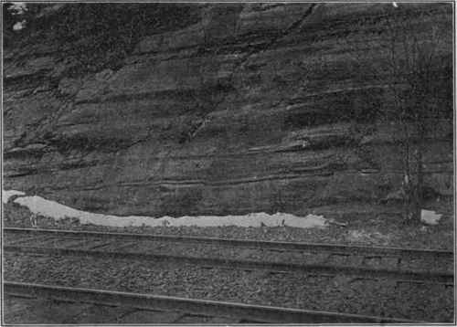
Fig. 71. - Glacial grooves on sandstone cliff; Delaware Water Gap, Pa.
(1) In cross-section a glacial valley is U-shaped, with broad bottom and steep or vertical sides. If the upper portion of the valley was not occupied by the ice, the slopes may be gradual down to the former level of the ice, where they become abrupt. (2) Glacial valleys are often straight and open for long distances; they may have spurs alternating from the opposite sides, but these spurs are truncated by the ice, and, if the action persisted sufficiently long, the spurs will have been entirely removed. (3) The tributary valleys do not enter the main valley at grade, as they normally do in the case of rivers, but enter at the sides of the main valley much above its bottom and hence are called hanging valleys. The explanation of this peculiar arrangement is that the smaller, tributary glaciers could excavate their beds much less rapidly than the trunk ice-stream. " Although there is no uniform height at which these side valleys enter the main trough, in general it is true that, the smaller the tributary valley, the higher its mouth lies above the main valley bottom." (Tarr.) Hanging valleys may be formed in other ways than by glaciers, but while they are common in glaciated regions, elsewhere they are only occasional. (4) Glaciers may erode their valleys below sea-level, because they exclude the sea water, as rivers cannot do.
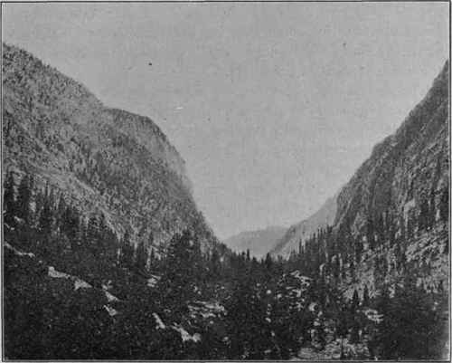
Fig. 72. - U-shaped glacial valley; Kern Canon, Cal. (U. S. G. S).
Glaciers flowing from high mountains head usually in large amphitheatres, or "cirques," caused by the lateral plucking of the rocky walls by the fields of ice and snow. Each cirque slowly retreats upward, thus often reducing the divides between them to extremely sharp "knife-edges," as is conspicuously displayed in the Sierra Nevada of California.
The part of a glacier which descends below the snow-line is in summer exposed to continual melting and may be more or less completely covered with running water. Surface streams flow in channels, which they melt for themselves, until they meet with a crevasse, down which they pour in cataracts. As crevasses are continually formed at the same spot (see p. 153), such a cataract may remain stationary for a long period and wear out a cylindrical pot-hole, exactly as is done by a cascade in a stream.
Continue to:
My Books

