Adjustment Of Rivers
Description
This section is from the book "An Introduction To Geology", by William B. Scott. Also available from Amazon: An Introduction to Geology.
Adjustment Of Rivers
However the streams of a district may have been established in the first instance, whether they were consequent, antecedent, or superimposed, they are liable to changes more or less profound and far-reaching. These changes, which belong to the normal development of the drainage system and are not dependent upon diastrophism, are due to adjustment of the streams to the rock structure of the district, the streams searching out the lines of weakness and least resistance, and everywhere taking the easiest path to their destination. The upstream extension of branches and the shifting of divides result in the capture of streams, or parts of such, by others more favourably situated, one master stream gradually absorbing many smaller ones which had originally been independent.
A divide, or water-parting, between two streams is gradually shifted by the lengthening of the more favourably situated stream, or of one of its subsequent branches. This more favourable situation may be because it has a shorter course and greater fall, giving a swifter flow, or because it flows at a lower level, giving greater fall to its tributaries, or because its course is through soft and easily eroded rocks, while its rival is embarrassed by hard rocks and ledges. Another favourable circumstance which may decide between streams otherwise equal is given by the attitude of the strata. In regions of inclined strata, as we have already learned, the escarpments formed by outcropping ledges of harder rocks tend to migrate in the direction of the dip. As such escarpments frequently form divides between minor streams, the stream toward which the escarpment migrates will be at a disadvantage. This shifting of divides is a very slow process, but after a long time of insidious advance the actual capture and diversion of part of a stream may be quite suddenly effected.
Stream capture may be effected in a great variety of ways, but a few examples must suffice. We may, in the first place, suppose two neighbouring streams following roughly parallel courses, but owing to the original conformation of the region, flowing at different levels. The stream that flows at the lower level will allow greater fall to its tributaries, which will thus work upward more rapidly. One of these tributaries will eventually work its way through the divide and tap the rival stream, all of whose waters above the point of tapping will be diverted to the main stream which flows at the lower level.
The same mode of capture may be effected in the case of two streams which head on opposite sides of the same divide, one of which has a much steeper grade than the other. The stream which has the steeper slope will work headward more rapidly, and will eventually tap the head-waters of the opposite stream. This method is illustrated in the Catskill Mountains, which are carved out of a table-land sloping gently westward, but having a steep escarpment on the eastern face, with recesses in which easterly flowing streams were established. At the same time westwardly flowing streams formed on the gently sloping summit level. The eastern streams, especially the Kaaters Kill and Plaaters Kill, have a steep descent and swift flow and have thus been able to extend their heads rapidly and to capture and divert many tributaries of Schoharie Creek, which runs westward. These captured tributaries keep their original course in the direction of Schoharie Creek, but make sharp turns and reverses to join the capturing streams. The Yellowstone Lake once discharged southwestward into the Snake River. The Yellowstone River was then a small stream, but was favourably situated for establishing a steep gradient as it flowed over a plateau of comparatively soft lava.
Extending upward, the stream tapped the lake and reversed the direction of its discharge. Another method of stream capture is well illustrated by the Delaware, the Potomac, and other transverse rivers which have cut deep gorges through the Appalachian ridges. Suppose two parallel transverse streams flowing across a gently sloping peneplain which is composed of tilted rocks of different degrees of hardness. In the manner already explained (p. 482) these streams cut gorges through the ridges of hard rock, while longitudinal valleys are worn out along the strike of softer strata, which valleys are occupied by tributaries of the transverse streams. If one of the two transverse streams be considerably larger than the other, it will saw its way through the hard ridges at a correspondingly faster rate and establish a lower base-level for its tributaries. One of the tributaries with its more rapid fall will be thus enabled to shift its divide at the expense of a branch of the rival transverse stream, capture it, and by reversing the direction of its flow draw off the waters of the smaller main stream above the point where its captured tributary entered it.
Or a tributary of the larger main stream may push its way up a longitudinal valley until it taps and diverts the smaller transverse stream without the intermediation of any tributary of the latter. Examples of both of these varieties of capture may be found among the Appalachian rivers; an excellent illustration of the latter method is given by the Potomac and Shenandoah.
When the Potomac was beginning to cut its gap through the Blue Ridge at Harper's Ferry, a smaller stream, Beaverdam Creek, was cutting a similar gorge through the same ridge a few miles to the south. The Shenandoah was then a young and short tributary of the Potomac, which it entered from the south, flowing through the longitudinal valley which was opening along the strike of the softer strata to the west of the Blue Ridge. As the Potomac is much larger than Beaverdam Creek, it cut its gap much more rapidly, thus giving a steep and swift course to the Shenandoah. The latter pushed its way up the longitudinal valley until it tapped Beaverdam Creek and captured its upper course, diverting its waters to the Potomac. Beaverdam Creek no longer flowed through the gorge which it had cut in the Blue Ridge and which was thus abandoned and became a "wind-gap," the beheaded Beaverdam now rising to the eastward of the abandoned gorge. This gorge is known as Snickers Gap. The great number of wind-gaps in the Appalachian ridges show how frequently the capture and diversion of smaller streams by larger ones has been accomplished among those mountains.
Figures 248 and 249 show two stages in the evolution of a river system. Figure 248 represents the first stage, in which several transverse streams, a, c, e, f, g, are breaching the escarpments indicated by shaded lines. Of these streams, c carries the most water, and will therefore deepen its gorges through the hard ridges more rapidly than the others, and give its tributaries the advantage of a greater fall. In the second stage (Fig. 249), c has captured the upper courses of all the other streams except g, which has not yet been reached. The branch l has captured a, beheading it, diverting the portion a" and reversing the portion a'. Similarly, m has captured and divided e, n has done the same with .b, and p with d, while g must eventually suffer the same fate. Wind-gaps will be left in the ridges where the captured streams once crossed them.
In regions of folded rocks thrown into a series of parallel anticlines and synclines, the process of adjustment may become exceedingly complicated. Suppose an original consequent stream flowing in a syncline of hard rock considerably above base-level, whose subsequent branches have opened out valleys in softer rocks along the crests of the anticlines, where the harder surface stratum is first cut through. The extension and junction of these subsequent branches may offer a more advantageous course than the hard syncline, and cause the latter to be wholly or partially deserted. The streams originally flowing in the synclinal troughs may gradually be shifted to the degraded anticlines which, as we have seen, are wasted away more rapidly and this transfer is facilitated by the fact that the synclinal troughs have very gentle slopes longitudinally, giving but small velocity to the rivers which flow in them.
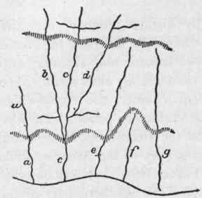
Fig. 248. - Evolution of a river system, first stage. The shaded lines represent escarpments of hard rock. (De Lapparent).
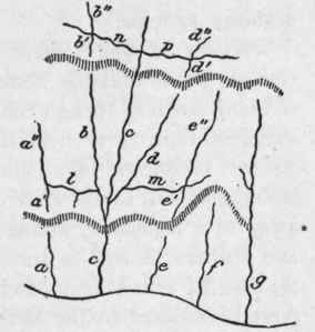
Fig. 249. - Evolution of a river system, second stage. (De Lapparent).
A thoroughly mature drainage system is characterized by a complete adjustment of its streams to the structure of the rocks. The rivers as finally established are thus apt to be a patchwork of streams captured and diverted, and the result of adjustment is the production of a system often radically different from the original one. Even after a river system has become maturely adjusted, a reelevation of the country may produce a new and entirely different adjustment, by changing the relation of the folds and outcrops of hard and soft strata to the base-level. A region of great antiquity which has repeatedly been worn down and reelevated will have experienced many revolutions of its drainage systems.
Warping of the surface nearly always produces extensive changes in the drainage systems affected by diverting the course of many streams, though the master streams may excavate with sufficient rapidity to hold their channels as antecedent rivers. As will be shown in a subsequent chapter, the Appalachian Mountains had, by the close of the Cretaceous period, been worn away to a peneplain, across which the Delaware, Susquehanna, and Potomac flowed in transverse valleys to the Atlantic, while the New River in Virginia and the French Broad in North Carolina flowed westward to the Mississippi. The southern part of the peneplain was drained by a longitudinal river called the Appalachian River, and smaller streams running westward and southwestward to an extension of the Gulf of Mexico drained the southwestern side of the peneplain. Next followed an up-warping of the peneplain along a north-south axis, through which the northern rivers continued in their old courses, but one of the southwestern streams extended headward and captured the headwaters of the Appalachian River. Still another upwarp succeeded, this time on an axis running nearly east and west through northern Alabama and Mississippi, in consequence of which a tributary of the Ohio extended itself southward and captured the southwestern stream which had before beheaded the Appalachian River. Thus arose the Tennessee, which enters the Ohio after such a curious course and which is made up of parts of three originally independent river systems, and in its changes records the history of the region through which it flows.
Continue to:
My Books

