Chapter XX. Topography As Determined By Faults And Joints
Description
This section is from the book "An Introduction To Geology", by William B. Scott. Also available from Amazon: An Introduction to Geology.
Chapter XX. Topography As Determined By Faults And Joints
Not uncommonly faults have no direct effect upon topography, or whatever influence they may originally have exerted has been lost, denudation having worn down the two sides to the same level or to a continuous slope, so that no evidence of the fault appears in. the surface forms, but must be indirectly obtained. When newly formed, a fault is accompanied by the scarp, as a long line of cliff or bluff. As modern faults teach us, displacements of great throw are probably produced by repeated movements along the same plane of fracture, and thus require long periods for their completion; and during this process of dislocation erosion is actively at work, especially upon the scarp, which is most exposed to attack. The length of time during which the scarp persists, as in the case of topographical features generally, depends upon the activity of weathering and the resistant power of the rock. Well-preserved and lofty fault-scarps are therefore very much more frequent in arid than in pluvial climates. Long before its removal the scarp is deeply dissected and made rough and craggy, so as to resemble a mountain range.
Examples of this kind of topography are to be seen on a grand scale in the arid parts of the West, their preservation being due in part to the geologically late date of the dislocations, and in part to the aridity of the climate which makes denudation very slow. The imposing lines of cliff which demarcate the plateau of the Colorado on the western side are fault scarps, and the plateau itself is crossed by many minor faults which still form prominent surface features, though much modified by erosion and some of them quite disguised.
The Great Basin, which is enclosed between the Wasatch Mountains on the east and the Sierra Nevada on the west, and comprises nearly all of Utah and Nevada, is bounded by the enormous fault-scarps of those ranges. The Sierra Nevada escarpment has a throw estimated at 15,000 feet, though this has been much reduced in height, and is deeply dissected by erosion, so that its true nature is not immediately apparent. On the eastern side the Wasatch escarpment is similarly dissected, but there have been additional very recent movements along the old fault-planes, and the lately formed scarps, though low, are remarkably fresh and unchanged even in incoherent materials. The Basin itself is traversed by many north and south faults, and the blocks included between these parallel lines of dislocation are tilted and form great scarps, but with gently inclined top. Each block thus has an abrupt side, the rugged and worn scarp, and a long, gently sloping side, which gradually inclines to the foot of the next parallel scarp. Denudation has carved these tilted fault-blocks into ridges and peaks, giving them the appearance of an ordinary mountain range, when seen from the escarpment side, but formed in an entirely different manner from true mountains of folding, and known as block mountains.
In southern Oregon the plateau of basalt has been fractured into a series of blocks, which are tilted, with very gentle ascent on one side, ending in an abrupt scarp on the other. These have been so little affected by erosion that their true character is immediately apparent.
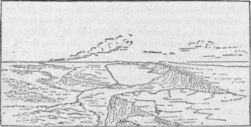
Fig. 238. - Abert Lake, Oregon. The line of cliffs is a fault-scarp. (Russell).
The Adirondack" Mountains display a topography which is strongly dominated by systems of faults; their general character is thus described by Professor Kemp: "The Adirondack region . . . is mountainous in its eastern half and has its highest peaks near its centre, but on the west the mountains disappear and the area becomes a plateau ranging from 2000 feet above tide gradually downward to the west until it is but slightly higher than Lake Ontario and the St. Lawrence. . . . The mountains are arranged in visible northeast and southwest lines, and are often very steep if not positively precipitous in the portions that look to the southeast or northwest. There are also other steep faces nearly at right angles with the above, but they are less pronounced." These features are due to three intersecting systems of faults, the principal one of which is northeast and southwest and determines the general trend of the mountains. The second system, which trends northeast at right angles to the first, is less important, and acts chiefly in cutting the ridges into separate blocks. The third series, with north and south trends, is quite subordinate in its effects.
The faults extend southward for many miles from the mountains into the plain, and some of them still retain their scarps.
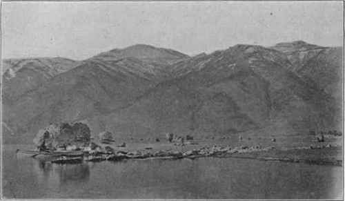
Fig. 239. - Sierra Nevada fault-scarp, Mono Lake, Cal. (U. S. G. S).
In Chapter XIII (Fractures And Dislocations Of Rocks) (p. 347) we learned that a block isolated by faults hading away from it on all sides, so that the block is on the upthrow side with reference to the area all around it, is called a Horst, a name adopted from the German for lack of an English term. The Horst structure is thus much like that of the block mountains of the Great Basin and the Adirondacks, except for the direction of slope in the fault-planes and for the fact that there is usually no relation between the strike of the beds and that of the faults. Several examples of Horst mountains occur in Europe, such as the central plateau of France, the Vosges, the Black and Thuringian Forests, and the Hartz Mountains. These uplifts are composed chiefly of ancient, very strongly folded and hard rocks, from which most of the covering strata have been removed by denudation, and rise quite abruptly from the comparatively undisturbed strata of the surrounding lowlands.
Continue to:
My Books

