Topography As Determined By Faults And Joints. Continued
Description
This section is from the book "An Introduction To Geology", by William B. Scott. Also available from Amazon: An Introduction to Geology.
Topography As Determined By Faults And Joints. Continued
Along the entire eastern coast of Asia the topography is controlled by gigantic systems of faults. The zigzag mountain ranges which bound the coastal plains on the west have a general trend approximately parallel to the coast, and mark a series of great faults with downthrows to the east. The coastal plain itself is divided into a series of more or less parallel blocks by step faults, also with downthrows to the eastward, resulting in a system of terraces, which, however, have not flat, but inclined tops, because of the tilting of the blocks, much as in the block mountains of southern Oregon, though on a vastly larger scale. An east-west section through northern China shows three such enormous blocks, the Mongolian block on the west, the Japanese block on the east, with theManchurian between; the Japanese block is partly submerged, making the outer portion an island, as is true of the whole chain of islands which fringes the eastern Asiatic coast. These disfocations may be followed from the Tropic of Cancer to the Arctic Circle and through sixty degrees of longitude.
Not only are the grand features of topography in eastern Asia dominated by gigantic fault systems, but the minor features indicate similar control. The Korean peninsula, for example, has its topography determined by systems of intersecting faults, of which the principal series extends from N.N.W. to S.S.E., and the whole country has been compared to a chess-board of fault-blocks. Japan is divided into two parts by a great transverse fault, the fossa magna, north of which the island has a northerly trend and is dominated by fault lines, while south of the fossa the island turns westward and is controlled by the axes of folds.
Faults frequently determine the location of valleys, either by affording convenient courses which are taken possession of and excavated by streams, or directly by trough faulting, that is, parallel faults hading toward each other, including an elongate sunken block. A single fault may lead to the formation of a valley when followed by a stream. Fault valleys are very common in the Sierra Nevada and Great Basin; and in the Coast Range of California a series of valleys, together more than 400 miles long, has been excavated along the fault line which is the seat of the recent earthquake disturbances. The lower Hudson flows in a fault valley, of which the Palisades form the scarp, and in the Adiron-dacks the drainage is so largely along intersecting fault lines that its regularity is very striking and has occasioned the descriptive term of " lattice drainage " (Brigham); the zigzag course of the Au Sable Chasm is determined partly by faults and partly by joints. The valley of the Rhine above Strassburg is a great trough-fault included between the Black Forest highlands on the east and the Vosges Mountains on the west, both of which, as we have seen, are Horst mountains.
The trough is very deep and is nearly filled with river deposits, which indicates the gradual character of the dislocating movements. Other European examples of such trough valleys are the basin of Lake Garda in northern Italy, the Christiania fjord in Norway, and the Gulf of Patras and Straits of Corinth in Greece. Such valleys are likewise extensively developed in Mongolia and southern Siberia; the basin of Lake Baikal is in a trough valley. The most remarkable known instance of trough faulting is the great Rift Valley of eastern Africa, which begins about 150 S. lat., and after a short course sends off to the northwest the Central African branch, in which are situated lakes Tanganyika, Albert Edward, and Albert; both branches are also the seat of extensive volcanic action. The main valley continues northward from Lake Nyassa and contains Lake Rudolph and several smaller lakes; passing between the plateaus of Abyssinia and Somaliland, it extends to the Red Sea, which is itself regarded as being but a very deep part of the same great downthrow inundated by the sea. At the northern end of the Red Sea, the Gulf of Akabah, on the east side of the Sinai Peninsula, is an extension of the trough which, growing shallower, rises to the land and keeps its northerly direction for a long distance.
Growing deeper again, it becomes the basin of the Dead Sea, the surface of which is 1300 feet below sea-level, and the valley of the Jordan, and north of that, the valley of the Orontes, reaching nearly to Antioch. The valley of the Jordan and the Dead Sea is enclosed between parallel faults and mono-clinal folds, the descent being very abrupt on the eastern side, while on the west it is more gradual and by means of several terraces and scarps. In Africa the great Rift Valley is not bordered by mountain ranges, but cuts through high plateaus, and the form of the valley, with its constantly rising and falling bottom, shows that it is not a valley of erosion, but one of tectonic depression.
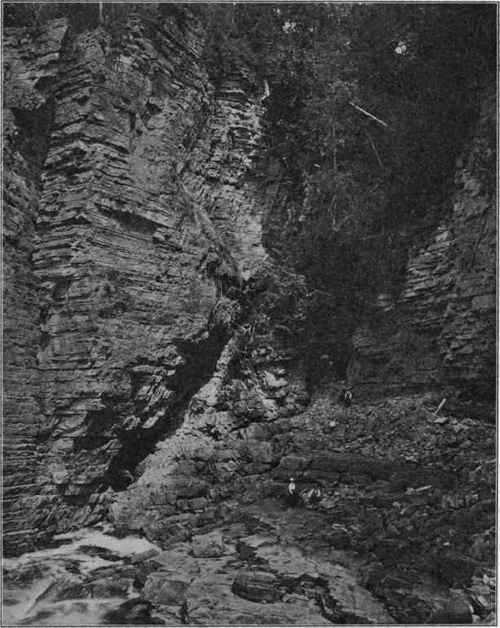
Fig. 240. - Normal fault, Au Sable Chasm, N.Y. (Photograph by van Ingen.) At this point the stream leaves the line of fault to follow a jomt-plane.
If this interpretation, which we owe to Suess, is correct, this vast dislocation extends through fifty degrees of latitude, and is one of the most striking structural features of the earth's surface.
Faults, especially those of large throw, frequently bring rocks of very different degrees of hardness into close juxtaposition. If the harder rocks are on the upthrow side, then the scarp' may persist for a very long period, because they are so much more slowly worn away than the softer rocks of the downthrow. If the latter is composed of the harder rock, the scarp is first eroded away, and then continued denudation, removing the softer rocks more rapidly, forms a scarp on the downthrow side, a reversed scarp, so to speak, due entirely to differential erosion. In other words, the hard rocks will eventually be left standing at a higher level than the softer ones, whether they are on the upthrow or downthrow side, and thus conform to the general rule of topographic development, provided the region stand sufficiently high above base-level.
Under these circumstances, faults of very high geological antiquity may continue to dominate the topography of the faulted region. A classical example of this is given by the Central Lowlands of Scotland, which lie between the Highlands on the north and the southern Uplands, and consist chiefly of quite soft and easily destructible rocks, while the higher areas which bound them on each side are made up of much more resistant rocks. When the rocks on the two sides of the fault-plane differ notably in hardness, then the transition from higher to lower ground is well-defined and abrupt, but the transition is gradual and by gentle slopes when the difference in hardness is small. The great faults, with throws sometimes amounting to 6000 feet, which demarcate the Lowlands, are very ancient, but they still control the main features of topography.
When the faults pass through strata of approximately uniform durability, the scarps are removed with a rapidity which is chiefly dependent upon the climate, because the upthrow side is exposed to attack and the downthrow is an area of accumulation. In such rocks all surface evidences of the fault are removed, and the very existence of the dislocation is often very difficult to detect. Unquestionably, countless undetected faults remain to be discovered even in well-known regions.
Unless interrupted by diastrophic movements, the progress of denudation must eventually remove all surface indications of faults, however great the difference in hardness between the rocks of the upthrow and downthrow sides. When the region is base-levelled, or reduced to a peneplain, no fault-scarps will be apparent. On the other hand, the beginning of a new cycle of denudation, through the upheaval of the faulted area and the rejuvenation of the erosive forces, may result in the reappearance of the scarps, provided the rocks on the two sides of the fault differ notably in hardness. In this case the harder will stand above the level of the softer, whether they are on the upthrow or the downthrow side. If the dislocations have not brought together rocks of different resisting powers, then reelevation, not accompanied by renewed displacements along the old fault-planes, will not bring the scarps again into prominence, though newly established streams may take advantage of these lines of weakness in trenching their channels.
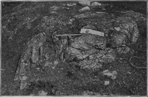
Fig. 241. - Great thrust, near Highgate Springs, Vt. The upthrow side has been denuded away and the hammer spans the thrust-plane, connecting beds which are stratigraphically many thousands of feet apart. (U. S. G. S).
From what has been said it is sufficiently evident that faulting plays a very important part in the formation of topographical as well as of structural features, and to faults may be added thrusts, though the importance of the latter is relatively less, for thrusts occur among violently compressed and folded rocks, while faults are found chiefly in strata which otherwise are not greatly disturbed.
Continue to:
My Books

