Coal
Description
This section is from "The American Cyclopaedia", by George Ripley And Charles A. Dana. Also available from Amazon: The New American Cyclopædia. 16 volumes complete..
Coal
Coal, a term now commonly used to denote all kinds of mineral fuel, though formerly applied to the glowing embers of wood, and more recently to charcoal. English and German writers until a very recent date treated of mineral fuel as pit coal, Steinkohle (stone coal), etc.; but at the present time, when wood and charcoal are fast giving place to the mineral varieties of fuel, the term coal is applied to that class of this fuel in general use. In England and the western states of America, where anthracite is but little used, coal or coals mean the bituminous variety, but in the eastern states the term also includes anthracite. In the east the former is called bituminous coal, while in the west the latter is termed anthracite coal, using a superfluous suffix. Under the term coal we may therefore embrace all classes of mineral fuel that will ignite and burn with flame or incandescent heat. The prominent varieties are denominated anthracite and bituminous coal; though a third variety is improperly termed lignite, which more strictly denotes a class of carbonized or partially charred wood, termed wood coal or brown coal. (See Brown Coal.) - The usual geological division, which places all true coals in the central or carboniferous era, is misleading and incorrect, because true coals are found as well in the so-called "false coal measures," and the more recent formations, as in the carboniferous.
The common method, of dividing coals into two principal classes, as bituminous and non-bituminous, is likewise unsatisfactory; while the local technical nomenclature, denoting the ever-changing and numerous varieties of coal, as hard, soft, white-ash, red-ash, fat, dry, cherry, parrot, orrel, etc, are unscientific and confusing. Both anthracite and bituminous coals are divided locally into numerous varieties or grades, but where the one ends and the other begins neither the miner nor the chemist has yet determined. They are both frequently found in the same measures, and even in the same bed, within short distances of each other. The combinations of carbon, hydrogen, oxygen, and nitrogen with earthy impurities, to which the term mineral fuel may be properly applied, are infinite, ranging through all the grades of coal, from the hard, dense anthracite to the asphaltic varieties, and from the solidified petroleum to the gaseous naphtha. For greater simplification and convenience we shall herein denote the prominent varieties as carbonaceous, hydrogenated, oxygenated, and hydrated coals; and incidentally as anthracite, bituminous, cannel, free-burning, non-caking or block coal, and caking or coking coals.
Though the term carbonaceous coal would, strictly speaking, denote all kinds of mineral fuel in which carbon is the base, we use the term as applying more exclusively to the anthracite varieties, in which fixed carbon is the characteristic element. For a full description of this class see Anthracite. - Hydrogenated coal is the strictly bituminous or caking kind, and the most available for the production of coke. In this coal hydrogen is the predominating element, in its gaseous or volatile constituents, though both oxygen and hydrogen are generally present in such coals in nearly equal parts. But when the oxygen predominates to any great extent, the coal loses its adhering or coking qualities; and when hydrogen is present in considerable quantities, the coal is more or less fat, or rich, according to the common expression. In connection with a large percentage of fixed carbon, 4 to 5 per cent, of hydrogen will produce the largest amount of coke; but even 6 per cent, of hydrogen with 8 to 10 per cent, of oxygen fails to produce available coke. The term hydrogenated, therefore, denotes more clearly than any other the numerous varieties of bituminous coals variously denominated coking, caking, fat, rich, or close-burning coals.
They do not burn freely, but meet and run into a mass or cake, from which the volatile parts are slowly burned, leaving coke or the carbonaceous portion in an incandescent state as fixed carbon, which has the properties of anthracite, and burns much the same, though it is porous and more easily ignited. - Oxygenated coal embraces the free-burning, non-caking varieties of bituminous coal, the "block" or furnace coals of our western bituminous fields, the so-called lignites of the Rocky mountains and the far west, some of the cannel varieties, most of the splint coals, and the hard or dry bituminous coal of the English mines. In this class of coal oxygen predominates in the volatile portions, and the coal burns freely without caking, or meeting and adhering in mass. Of this kind there are two prominent varieties. One is comparatively hard and burns to ash without crumbling, and constitutes the blast furnace or block coal, and most of the cannel and splint coals. The other is soft, frequently hygroscopic, often heterogeneous in composition, divided both horizontally and perpendicularly by earthy impurities, and sometimes is a mass of semi-crystallized and loosely combined cubes.
This kind disintegrates in the atmosphere, or under high temperatures, and cannot be used in the blast furnace under the existing conditions. - Hydrated coals are generally of the so-called lignite varieties, though all classes of coal contain more or less water, as the following table exhibits. The hard, impure anthracite of New England frequently contains from 5 to 15 per cent, of water, while the soft tertiary coals of the far west contain an equal amount; and the purest coal contains a small amount of hygroscopic matter. As a cliiss, however, the more recent coals of the Jurassic and tertiary formations contain the largest amount of water; and to these we apply the term hydrated, to distinguish them from the oxygenated, though the former contains even more oxygen than the latter.
ANALYTICAL TABLE OF MINERAL FUEL.
No. | NAME AND LOCALITY. | Density. | Free Carbon. | Total Carbon | Hydrogen. | Oxygen. | Water. | Ash. |
1 | Peat, general... | .. | .. | 28.09 | 5.93 | 30.87 | 30.05 | 5.62 |
2 | Lignite, Rocky Mts.. | 1.280 | 24.00 | 64.99 | 8.76 | 10.42 | 10.56 | 5.27 |
3 | Anthracite, " ... | 1.300 | ? | 74.37 | 2.58 | 10.00 | 5.20 | 7.88 |
4 | Cannel coal, W. Va... | 1.300 | 23.00 | 82.00 | 5.16 | 8.04 | 2.26 | 2.55 |
5 | Block coal, Penn., W. Va., O., Ind.... | 1.275 | *30.00 | 82.92 | 6.09 | 10.00 | 2.00 | 1.49 |
6 | Caking coal, general......... | 1400 | *15.00 | 85.90 | 5.46 | 5.00 | 2.00 | 1.04 |
Cakin coal, rich gas... | 1 1.360 | 25.00 | 84.00 | 6.00 | 5.00 | 3.00 | 2.00 | |
7 | Hard anthracite, penn.. | 1.560 | ? | 94.00 | .40 | 1.26 | 2.30 | 2.50 |
8 | Soft anthracite, " ................ | 1.450 | ? | 87.00 | 2.50 | 3.50 | 2.00 | 4.00 |
9 | Dense anthracite, New England..... | 1.780 | .. | 80.00 | .. | .. | 10.00 | 10.00 |
Nos. 1 and 2 of the foregoing table may be. classed as hydrated coals; Nos. 3, 4, and 5 as oxygenated; No. 6 as hydrogenated; and Nos. 7, 8, and 9 as carbonated. The last (No. 9) frequently contains a large amount of water; but this is not always the case, while carbon is the only combustible element present of any value as fuel. - The bituminous classes are frequently termed gas coals, steam coals, furnace coals, oil coals, coking coals, and household coals. All coals now used largely as fuel will produce more or less carbonic oxide gas; but those containing a large proportion of volatile combustible matter are preferred. Illuminating gas requires a large proportion of free carbon and hydrogen, which can be reduced to gas at a low temperature. The same coal, however, may produce a large amount of excellent coke at a high temperature; because a large portion of the carbon, which distils as volatile matter under a comparatively low temperature, known as cherry red (750° to 900° F.), becomes fixed carbon under an intense heat. But a good coking coal does not require a large amount of volatile matter. A small percentage of hydrogen is necessary to produce the caking quality.
Both gas coal and coking coal may therefore be denominated hydrogenated coal, because the other varieties under this nomenclature are not generally as available for these purposes. The best oil coals are also of this class, though the cannel varieties are preferred, because they usually contain a large amount of volatile combustible matter, and distil at a low temperature. While oil may be produced from these coals at 000° to 750° F., a slight increase of temperature produces permanent gas. The best steam coals may belong to any of the prominent varieties, as herein classified, but the coals most preferred are such as will not crumble under heat, hard and yet free.burning, durable under combustion and productive of an intense heat. Blast furnace coals, exclusive of coking coal, belong either to the carbonaceous or oxygenated classes, and are usually classed as anthracite, block, or splint coal. Carbon is the element required, but blast furnace coal is also required to burn without crumbling, and to be hard enough to resist abrasion in the furnace, and descend to the zone of fusion without disintegration.
Household coal may be of any denomination; but the carbonated and oxygenated coals, as a rule, are the best, and of these the anthracite and cannel varieties are the most desirable, the first for culinary purposes, and the second for cleanliness, ready ignition, and combustion. A large number of the other coals are also much used, and by some preferred. Both block and splint coals make excellent household fuel, while the Pittsburgh coal of bed G possesses the qualities of a good household, gas, and coking coal, which is a rare combination of the combustible elements of coal. - The terms semi.anthracite, semi.bituminous, and bituminous, generally applied to coals, are arbitrary, frequently misapplied, and far from significant of their true character. That which is known as anthracite in one locality is frequently termed semi.anthracite or semi. bituminous in another. It is always difficult to distinguish where the one begins or the other ends. Finally, the division of mineral fuel according to the mechanical structure and appearance of the coal is perhaps more expressive and significant for general use than the chemical nomenclature.
Thus, the hard anthracite is massive, dense, and conchoidal in fracture, and of a rich, glassy, sub.metallic lustre; while the softer varieties, approaching the bituminous class, are less massive in structure, less dense, and more cubical in fracture, and of a silky black semi.crystalline lustre. Block coal, now celebrated as blast furnace fuel, is massive in structure, of minimum density, oblong or block.like in fracture, and of a satin.black lustre. It is a medium between ordinary bituminous and cannel coal. Splint coal has a laminated structure, breaking into plates horizontally, or with an irregular splinty fracture perpendicular to the strata. It appears to be composed of alternate layers of bituminous and block or cannel coal. In the former hydrogen seems to predominate, while in the latter oxygen is generally in excess. Cannel coal is various in structure. It is sometimes block.like, often laminated, and occasionally conchoidal; but under heat, or in burning, it generally, if not always, splits into thin plates or layers parallel to the strata. When pure it is of a rich satin.black appearance; but when mixed with earthy impurities, and often in connection with bituminous coal, it has a dull, charcoal.black, lustreless appearance.
The term cannel is a Lancashire technicality, and is from candle (pronounced can'l by the miners), because it ignites and burns like a candle when rich and pure. All kinds of coal vary considerably both in mechanical structure and chemical composition, but the cannel variety is less consistent than any other; often within the same basin, and sometimes in the same bed, it changes from a coarse, earthy bituminous or cannel shale, to a rich coal, and from bituminous, splint, or even block coal, to cannel, and vice versa. The gradations of carbon, hydrogen, and oxygen compounds, from the almost pure fixed carbon in anthracite, through the more volatile bituminous varieties of coal, to the free carbon and hydrogen of naphtha, are infinite; and no formula can truly express the relative proportions which limit these compounds to the various classes of coals, or as mineral fuel. The passage of the varieties of coal into each other often renders their exact definition impossible. The Albert coal, the Ritchie mineral, and the Boghead or Torbane hill cannel, and other asphaltic varieties, though true coals, are so nearly allied to bitumen, asphalt, or solidified petroleum, that both science and practical experience have been at fault in determining their classification.
In the celebrated lawsuit in Edinburgh, in 1853, many eminent authorities testified both for and against the designation of Torbane hill cannel as coal; and while three microscopists swore that it contained no trace of organic structure, four affirmed that it exhibited the clearest evidences of vegetable origin. Another lawsuit of this character was tried in New Brunswick, to determine whether the Albert mineral was coal or asphaltum. While the term coal is applied to the purer varieties, stratified in the earth, with a few exceptions, as beds, the same elements are variously combined as diamond, graphite, carbonaceous and bituminous shale, bitumen, asphaltum, solidified petroleum, petroleum, naphtha, etc.; and so gradual is the change from one to the other, that it is difficult to determine their limits by appearance, and chemistry has not yet settled their exact proportions.
* The amount of free carbon in these classes of coals ranges from 20 to 80 per cent.; and. as determined by analysis, this percentage is extremely arbitrary, depending on the temperature, time, and processes to which they may be subjected for the production of gas at a low or coke at a high temperature.
Analysis Of Cannel Coals
LOCALITY. | Sp. grav. | Volatile matter. | Fixed carbon. | Ash. |
Albert coal. New Brunswick.. | 1.129 | 61.74 | 36.04 | 2.22 |
Boghead cannel (Scotch).... | .. | 66.85 | 30.88 | 2.77 |
Grayson, Ky., "jet cannel"... | .. | 61.95 | 30.07 | 7.98 |
" " cannel.. | 1.871 | 62.08 | 14.86 | 23.62 |
Breckenridge, ky., cannel.. | 1.150 | 64.30 | 27.10 | 8.48 |
Torbane hill cannel... | 1.189 | 67.11 | 10.52 | 21.00 |
Boghead black cannel...... | 1.218 | 62.70 | 9.25 | 26.50 |
Boghead brown " ... | 1.160 | 71.06 | 7.10 | 26.20 |
Hardie's (Scotch cannel).... | 1.420 | 53.70 | 4.90 | 38.80 |
The bitumen of Cuba, the Albert coal, solidified petroleum of Ritchie co., W. Va., and petroleum, are similar compounds of hydrocarbons. An analysis of Albert coal by Gesner gave: carbon, 85.40; hydrogen, 9.20; nitrogen, 3.06; sulphur, trace; oxygen, 2.22; ash, 0.12.
FORMULA OF THE GENERAL VARIETIES OF COAL.
Constituents. | Anthra. cite. | Caking coal. | Cherry or Block coal. | Splint coal. | Cannel coal. | Lignite. |
Carbon... | 92.56 | 87.952 | 83.025 | 82.924 | 75.25 | 6400 |
Hydrogen.. | 3.33 | 5.239 | 5.250 | 5.491 | 5.50 | 5.00 |
Nitrogen___ | ? | ? | ? | V | 1.61 | ? |
Oxygen... | 2.53 | 3.800 | 8.566 | 8.847 | 18.88 | *26.00 |
Ash..... | 1.58 | 1.393 | 1.549 | 1.128 | 2.81 | 4.00 |
- The formation of mineral fuel, and the manner in which it was stratified among the rocks, are still problematical. Numerous theories have been advanced, which, however, are generally the opposites of each other, and none of them have been commonly accepted. Though many well established facts have been developed, but few of them can be reconciled with the prominent theories of coal formation, unless arbitrary or unnatural processes are employed. Some draw their conclusions from the existing conditions of the earth and the atmosphere, and infer that the processes of the present day were those of the primordial ages, with but little modification; while others argue that the natural phenomena or conditions of the past were different from those of the present, and draw their conclusions from geological and scientific facts no less evident than those inferred by the former theorists; thus tracing the creative agencies from the past to the present, inferring them from present data, instead of accepting the present as the normal condition. On some important facts they meet and agree, but generally disagreement is paramount. The prominent theories of coal formation are briefly given in the following statements. 1. The drift theory.
This supposes that the ancient flora, growing on the low, swampy shores of rivers, lakes, and seas, including both arborescent and aquatic plants, was torn from its habitat by floods or inundations, drifted by streams, tides, and waves far into shallow lagoons or seas, and deposited at the bottom as the nucleus of a coal bed, to which constant accumulations were added by the same means; presuming that vegetation would not decay in water, and that the mud and silt always accompanying such drift would not mix with the vegetable matter as sediment. Coal, however, is not mixed promiscuously with earthy impurities, but regularly and uniformly stratified between the sedimentary rocks. Or it is supposed by some that the constant drift of forest trees into the estuaries of rivers, such as the drift of the Mississippi to its delta in the gulf, and the drift of the Red river in Arkansas, has been the means of accumulating coal beds. These views, however, may be considered as obsolete, though prominent in our text books and still adhered to by a few eminent geologists. 2. The peat.oog or marsh theory.
* Part water.
This supposes that the vegetation which produced coal grew on the edges of shallow lakes or seas, or even far in toward their interior, and that it was deposited where it grew. This is modified by some, who believe that coal was produced chiefly by land plants, and that these were gathered into the coal basins by the over-How and inundation of the land caused by earthquakes or other paroxysmal violence; thus accounting for the interruption of vegetable growth, the formation of the rocky strata, and the alternate beds of coal, slate, shale, clay, limestones, and sandstones. Whether the one or the other of these views be adopted, an earthquake is necessarily evoked by the theorists. They presume that the sea is depressed or deepened to form the rocky strata, and elevated to form shallow marshes or bogs, in which vegetation again takes place, to be followed by successive interruptions and growths for each successive coal bed. While the growth of vegetation may be admitted according to this theory, the formation of the rocky strata and the alternate elevation and depression of the coal basins are unnatural, and cannot be accepted as geological facts, or even tolerated beyond a mere conjecture. 3. The marine theory.
This supposes that seaweed, or the hydrophites generally, formed coal; or, more comprehensively, the aquatic plants which grew up through the water, or had their roots in water. Among these were the ancient tree ferns, club mosses, sigillaria, lepidoden-dra, calamites, and perhaps the early coniferaB, all of which had long stemless trunks and wide-spreading tops, and are supposed to have grown in deep water, with their roots in the mud of the bottom, or the tire clays of the present day, and their branches on the surface of the water. These grew in water surcharged with carbonic acid, and perhaps with hydrocarbon, spreading their magnificent palm-like tops in an atmosphere abundantly charged with their elements of growth in perpetual summer, and under a warm and forcing temperature. The plutonic or internal heat of the earth produced this temperature, which was uniform during all seasons, both in the water and the atmosphere; while the influence of the sun could have had little effect through the haze of gaseous vapor, steam, and smoke. Under such circumstances, the most favorable to vegetable growth, the plants absorbed in their cellular tissue resinous juices or hydrocarbon oils, instead of the hygroscopic matter which we now term sap.
The rank and magnificent flora of the carboniferous eras, growing under these favorable conditions, must have been luxuriant beyond comparison; but to show the fecundity of seaweed at the present time, we may cite the vast accumulations of these insignificant hydrophites in the great Sargasso sea, which Humboldt computed to cover 260,-000 square miles of the surface of the ocean, in places so dense as to arrest the progress of vessels. In the former theories, the coal is supposed to be the result of the carbonized woody fibre of the plants. In this, the resinous sap or hydrocarbon juices are presumed to aid in the production of coal, and the land plants, or arborescent flora found in the rocky strata, to have had little influence in producing this result. This part of the theory seems natural and probable, but the same difficulties in the formation of the strata exist, when referred to abrasion of the shores by tides or waves, or the detrition of the older rocks by streams. 4. The petroleum theory.
This supposes that the hydrocarbon juices of the plant, forced out by the pressure of the strata and water under which it exists when deposited at the bottom of the coal basins, rose to the surface as petroleum, and floated beneath the foliage of the plants where they existed, but spreading evenly and uniformly on the surface of the water, whether covered by vecreta-tion or not. This accumulation of oily matter would preserve the successive growths of the plant, which added continually to the mass; and finally this would become heavier than water by the volatilization of the hydrocarbon, by the oxidation of the vegetation, and by the accretion of earthy matter from the dust and ashes of the atmosphere, produced by many active volcanoes. This theory is comparatively modern, and has been supplemented by the volcanic theory, which seems necessary for its proper solution, in the formation of the rocky strata, because it is apparently impossible to reconcile the wide distribution and uniform stratification of beds of pure coal, clay, slate, lime, and sand, without admixture or change of horizon, by the drift theory. But the volcanic theory of sedimentary formations lias given rise to a new or mineral theory for the production of petroleum and its resulting bitumen or coal.
We give the latter in advance of the former. 5. The mineral theory. This is but crudely defined, but the main arguments used in its support are these: Carbon, hydrogen, oxygen, and nitrogen, the constituents of coal, are constant elements in nature, and do not owe their existence to subsequent processes. They performed important functions in the creation of animal and vegetable life; and this fact proves prior existence. The organic processes are not necessary to their union, either as hydrocarbon or carbonic acid, or the many other compounds, as water, air, etc, which they form. The union of carbon with hydrogen or with oxygen required perhaps the intense heat of submarine volcanoes or other causes, in which water is decomposed and carbon disengaged from the rocks or molten lava. The examples of present volcanoes are cited in proof, because petroleum is found floating near them when they exist in or near water; while volcanic regions of the present time abound with asphalt or bitumen. It is maintained in Daddow and Bannan's "Coal, Iron, and Oil" that the petroleum or bitumen thus formed aided in the production of coal, in connection with the vegetable oils described above. G. The volcanic theory.
This does not relate so directly to the production of the material forming coal, as to the manner in which the strata containing it were formed. To describe this exhaustively would be to take in the whole science of geology. Briefly, the facts and arguments may be thus stated: All the sedimentary strata of the earth were formed in water. The first or earliest were crystallized by heat, and contain no fossils; but where subjected to heat, as in some portions of the anthracite coal measures, and in many other places, the later sedimentary rocks, which contain fossils, are crystallized, or metamorphosed, as it is generally termed, which means that they have been altered by heat or other causes since their formation. But according to this theory, all the great crystallized sedimentary rocks owe their character to volcanic influences or plutonic heat during the period of their formation, except such local strata as may owe their crystalline structure to other chemical action. This theory teaches that all the older sedimentary rocks were formed by the flow of lava into the great bodies of water which covered the earth before its mountains had any form beyond mere outline, and before rivers could have flowed, or valleys existed as dry land; because it is one of the facts of geology that the great or older sedimentary rocks were deposited in almost horizontal planes, and that their edges have been uplifted, and their planes plicated or folded more or less, as the subsequent effects of contraction.
The stratification of more recent formations on the upturned edges of the former indicate these relations. It is consequently inferred that the sediment could not have originated from the drift of rivers or the abrasion of shores, because these had but a limited if any existence, and could not have produced the vast accumulations of strata which form nine tenths of the earth's surface. But even if such sources existed, they could not produce the sedimentary strata, with their beds of ore and coal, clay, slate, lime, sandstone, etc, in their uniform order. The crystallization was effected by intense heat acting on the deposited material, liquefying the silicates and other bases in connection with alkalies or acids, and thus not only forming the harder rocks of the earth posterior to the granite, etc., but also crystallizing many of them. The material forming these strata were almost exclusively volcanic, thrown into the water in a molten condition, and almost instantly shivered to atoms in contact with water, which must have been more or less heated and agitated under these circumstances.
The natural result of such action would be to form the strata as they now exist, in great plates of sandstone, or shales, clays, and slates, according to density; while the thickness and the texture of the strata would depend on their remoteness from the volcanic sources. It is known that waves and tides will distribute mud and silt to a great distance, and that liquid silicate will float in water. The winds have also been known to carry the dust and ashes of volcanoes over a thousand miles, and many hundreds of miles in blinding clouds; and it is also known that volcanoes existed in almost countless numbers in the early stages of the earth's history, while trap or plutonic rocks have flowed from the liquid interior of the earth through still more numerous vents. But in addition to those extinct volcanoes, and trap or basaltic dikes now exposed to view, a far greater number are covered and concealed by the strata which they produced, or by subsequent formations. Limestones were formed by the combination of the liquid silicates or calcium with carbonic acid, during all periods of the creative ages, but the greater masses anterior to the coal, when the carbon was abundant and united readily with the oxygen of the decomposed water; but during later stages, when hydrogen became less volatile, union with this element was frequent where the intensity of the heat did not prevent it.
From this union we have our nests and pockets of graphite or coarser plumbago in the granite and gneissic rocks. At a later age, during periods of repose and reduced temperature, aquatic plants, the fucoids or sea algro, began to grow, the fossils of which are found in the Silurian, and more abundantly in the Devonian rocks; and during the carboniferous eras, both aquatic and terrestrial plants acquired their most luxuriant growth, while animal life had an almost contemporary existence. At this time a large portion of the earth's surface was dry land; but it is evident that the Appalachian and many other mountains in North America had but a limited existence as mere ridges, it* indeed they existed at all, and the larger portion of our continent was covered with water. Consequently neither river nor valley existed to any great extent. The vast area from the Blue Ridge to the Rocky mountains was one continuous sheet of water at the commencement of the carboniferous era, with perhaps a few anticlinal ridges standing as islands above its surface. After the deposition of the carboniferous limestone these islands became more numerous, and the sea more shallow.
The thickness of the coal measures indicates their depth at this period in the east, while in the west the additional rocks of the Permian and other formations reposing on the coal measures indicate greater depth. The depth of the basins at the commencement of the coal era could not therefore have been greater than at present, though it might have been considerably less, because it is a recognized fact that the contractions of the strata lifted the edges of the basins and depressed their synclinals, while the anticlinals have been likewise lifted or plicated since the deposition of the coal measures. Thus the growth of the coal plants must have been in the water of this wide sea, and around its low and swampy shores, into which neither river nor wave could convey drift or detritus; it was too expansive for any such theory. Yet in this wide sea, which for convenience we may call the Appalachian, the millstone grit was deposited from shore to shore; while the Potsdam and other rocks occupied a still greater area, and could have been derived from no other than volcanic or eruptive sources.
By this theory it is claimed that every developed fact of geology can be accounted for and reconciled with the deduced or theoretical conclusions; while other theories require unnatural or abnormal processes which are only conjectural. - It may be concisely stated that all these theories contain some elementary farts. In studying the smaller coal fields of Europe the drift theory seems probable; but in the great American coal fields this oldest and most popular theory is entirely inadequate. The peat-bog or marsh theory was invented to take the place of the former, and out of this grew the marine theory. These modifications, however, cannot be exclusive. A small portion of the sediment was derived from detritus, but a larger amount must have been volcanic. In many of the European coal fields trap rock was intercalated as beds, or injected as dikes posterior to the formation of the coal strata; and this action was more frequent during the coal period than since. Whether either or both the drift and volcanic theories be accepted, arborescent plants, growing on the shores or in the shallows, would be gathered either by the inundations caused by volcanic violence or by drift, and would mingle with the aquatic plants in the deeper water.
Thus the four modes would combine in the formation of coal; and while no single theory would be exclusively correct, each would be partially so. But while the mineral theory may or may not partially account for the production, it requires the petroleum theory to simplify and combine the four former theories; because, however the coal flora was precipitated, it must have been in mingled and irregular masses of mud, graphite, coal, and silt, just as we now find the earliest deposits of carbonaceous matter in all coal fields, unless we accept the formation of petroleum or resinous oils from the flora, condensed beneath the weight of rocky strata and water. In support of the mineral theory is the fact that all coal beds are largest and most productive in those portions of the coal fields where the temperature has been comparatively high. Where this was intense, the coal has been partially reduced to graphite; and where low, the coal beds are thin, as we shall notice in the sequel. But the petroleum and the resulting bitumen, which seem to form the purer and semi-crystalline portions of all coal beds, may have been exclusively derived from the expressed resinous juices of the plants; though the variation in structure and appearance of the several classes of coal, so striking in cannel and the common bituminous varieties, seems to be due more to their chemical composition than to their mechanical structure.
We find abundant proof that the coal plants contained but little woody fibre. The earliest fossil flora has left mere prints or impressions on the rocks, while the latest coal plants have left only a small film of carbonaceous matter even around the immense flattened trunks of the calamites, the lepidodendra, or other large species; but when found erect, or only partially flattened, the bulk of the tree is not carbonized wood, but a cast of its former self, filled with the rocky material by which it is surrounded. It thus seems evident that the primordial flora was composed of comparatively soft, pulpy, and cellular tissue, or that the trunks were hollow and reed-like in structure, and that their pores, if not the pith, were filled with resinous sap. It seems evident that plants of this kind could not have produced our immense coal beds by the carbonization of their woody fibre, because they contained but little if any hard wood or lignine. They grew in water, and did not require strength. Their wide-spreading tops on the surface, and their own buoyancy, supported them. Consequently, if coal or bitumen did not result from the expressed juices of the coal plants, it is difficult to conceive how our fossil fuels could have accumulated except from more strictly mineral sources.
The arborescent flora required and did contain much more hard fibre, even during the coal period, than the hydrophites; but the area of their growth must have been exceedingly limited when the entire horizon of the carboniferous rocks was under water. But as it is impossible to determine how many of the coal plants were of terrestrial growth, it is equally difficult to ascertain their influence in the formation of coal. It is probable that the largest portions were imbedded in the rocky strata rather than in the coal, because they must have been torn from their places by violence, and promiscuously scattered during times of great commotion; while the aquatic plants were most productive during seasons of repose. The consistency of plants depends on rapidity of growth as well as on the nature of their habitat. The tree of rapid growth is not as hard and dense as that of slow maturity; while the aquatic plant rarely produces the hard wood of the arborescent. Tropical climes produce dense masses of foliage, luxuriant and of rapid growth, but most of it low, weak, and of equally rapid decay; while temperate regions produce tall forest trees, hard, strong, and durable.
The natural productions of to-day indicate the results of greater temperature and an almost exclusively aquatic habitat for the. vegetation of the primordial ages. But if the ancient flora had not some preserving element, such as petroleum would furnish, the magnificent vegetable productions of the coal era would decay as rapidly as the tropical aquatic plants of to-day. The arborescent or forest trees of the present time are undoubtedly more massive, or contain more hard wood, than those of the coal period, and an acre of ordinary forest will produce more charcoal or carbon now than the same area would have produced then; yet it would require 74 mature growths of a forest embracing 65 trees per acre, each containing 240 cubic feet of solid timber, to produce 1,613 tons, or one foot, of coal; and, assuming the period of each mature growth to be 100 years, it would require 7,400 years to produce a single coal bed 3 ft. thick. Hard wood would be reduced, according to Dana, three fourths in weight and seven eighths in bulk, to form ordinary bituminous coal.
It seems evident, therefore, that our great coal beds could not have resulted exclusively from the woody fibre of the coal plants, which must have been almost entirely aquatic.
Fig.1. - The Process of Coal Formation.
References: a. limestone; b. shale; c, fire clay; c'. c', coal beds formed; d, slate; d' coal bed in course of formation; e, sandstone;f, water; g. surface of water, and petroleum or hydrocarbon oils; H, foliage of coal plants rooted in e.
Fig. 2. - Section of Mammoth, from the open quarry at the Summit Mines, Le-hfeh.
(See Coal Plants.) We cannot, however, escape the fact that charcoal, or the carbonized fibre of plants, exists in coal; but a careful examination of the strata in coal beds will demonstrate that the charcoal or carbonized woody portions exist in the impure partings, or in laminated streaks between the pure, homogeneous, and glassy portions of the coal. All coal beds, with very rare exceptions, are composed of numerous strata, in which the pure "benches" or strata are divided by impure coal, bituminous or carbonaceous shale, slate, and other imperfect or rocky partings. These strata of coal are from an inch to 4 ft. thick, but generally from 3 to 12 inches; while the partings of "bone" slate, or other coaly and earthy impurity, range from a mere glassy film to many feet, particularly in the great anthracite beds of Pennsylvania. In these partings, the impurities are often homogeneous, attached to the upper or lower portion of the pure coal strata; while the bone, which has always a dull charcoal-black appearance, and is too impure for use, is frequently found in streaks through the pure coal. The technical term "bone," however, is chiefly confined to the anthracite beds. In the bituminous districts the bony coal is termed slaty coal.
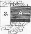
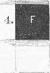
It is very difficult to distinguish traces of vegetable structure even in these impure partings, where the coal beds have been consolidated under the pressure of great masses of superincumbent strata; but around the northern margins of the Alleghany coal field, where we find unmistakable evidences of its original margin, both charcoal and vegetable structure are clearly manifest to the naked eye in the impure partings of the coal beds; while in the accompanying pure, glassy coal, even a powerful magnifying glass fails to detect organic structure, beyond vague conjecture. It is a singular and significant fact that the coal beds A, C, F (fig. 3), as far as they can be identified, of the anthracite regions in Pennsylvania, are generally the splint and cannel of the bituminous fields. These are the most bony or impure beds in the former; and, though exceedingly variable, changing from the rich cannel to impure bituminous shale, they are also the most impure coal beds of the western portions of the Appalachian coal fields. In studying our great American coal formations, the widest fields of investigation and the greatest diversity of phenomena are presented.
In describing these, the recognized facts and the geological evidences which have been developed will be given as concisely as possible, with such incidental notice as may be necessary to elucidate the relations between fact and theory. - The Appalachian Coal Formation. This embraces the Virginia and Pennsylvania anthracite fields, and the Alleghany coal field, with its numerous outlying basins, and by some is made to include the central coal field in Indiana, Illinois, and Kentucky. The term Appalachian is applied in geology to the system of mountain ranges which traverse the Atlantic states, including the Blue Ridge, the Blue or North mountains, and the Alleghanies, with their numerous intermediate and connected ranges, which are locally known by still more numerous names. These mountains are formed, with a few exceptions where peaks of granite and gneiss exist, by the upturned and plicated edges of the palaeozoic strata. The hard and massive rock of the Potsdam sandstone forms the crest of the Blue Ridge of the south, and its continuation, as the South mountains, the Highlands, and the Green mountains, in the northern states.
It is the base of the lower Silurian or Cambrian rocks, and forms an unbroken plate of uniform sandstone from the Blue Ridge ranges in the east to the Rocky mountains in the west, and from the great lakes to the gulf. The succeeding rocks of the Cambrian strata, Nos. II. and III., are quite as extensive, though their outcrops generally form valleys instead of mountains. In the table on page 735, No. IV. forms the crest of the North mountains, and Nos. IX., X., XI., and XII. the eastern escarpments of the Alleghanies. It will be noticed that all the rocks depreciate in the western direction, and some entirely disappear. The maximum thickness of the pakeozoic rocks of the Appalachian formations is 25,000 to 35,000 ft. in Pennsylvania and Virginia, while their minimum thickness in Illinois and Missouri is from 3,000 to 4,000 ft. In the eastern outcrops the sandstones and coarse shales predominate, while in the western the limestones are greatly in excess; and all the rocks are coarser in texture and more silicious in the former, and finer in texture or grain and more calcareous in the latter direction.
Many of the massive sandstones and shales of the cis-Alleghany outcrops entirely disappear west of the Ohio river, and none of them except the Potsdam, No. I., the Medina, No. IV., the Oris-kany, No. VI., and the millstone grit, No. XII., seem to be permanent; but these and the great limestones, Nos. II., III., V., VIII., and XL, are great plates of rock, with nearly uniform spread from the Blue Ridge to the Rocky mountains. The facts indicate that the source from which the materials forming these rocks were derived must have been in the east or eastward; while the evidences point to a volcanic rather than a detrital origin. That the heat was more intense near the volcanic regions of the east than in or near the great coal formations of the west, is clearly demonstrated by the crystalline (metamorphic) character of the rocks, the existence of anthracite coal, and the entire absence of bitumen; and that this is due to volcanic rather than plutonic or radiating internal heat, cannot be doubted, because the igneous rocks are more remote from the anthracite than the bituminous coal measures, or they are separated by a greater thickness of sedimentary rocks in the former than in the latter.
The greater thickness of the rocks, the coarseness of grain, the excess of both silicious and calcareous matter, and the increased thickness of the coal beds, are further evidences of their eastern and volcanic origin. The red shales of Pennsylvania and Virginia, No. XI. of the table on page 735, occupy the place of the mountain limestone. This contains a large amount of calcareous matter, and appears metamorphosed as limestones westward. They are preceded and followed, and sometimes interstratified, with evenly bedded flags of silicious character. These are often tinged with red, sometimes nearly white, but more frequently bluish, or darkened with blotches and specks of carbonaceous shading. The red color is derived from the red oxide of iron, which is abundant in these rocks in some localities. The flags seem to have been deposits of liquid silicate, and the succeeding conglomerate or millstone grit confirms this view, because this great and widespread rock presents unmistakable evidences of a quartzite formation.
In some places it exists as plates of white silica, compact and crystalline; in others, as veins of white quartz in mixed material; sometimes as masses of white quartz, irregularly deposited, occasionally as crystals, but generally as secretions or drops of white quartz, cemented with the silicious and calcareous mud in which they are deposited. The millstone grit has been generally considered as the base of the coal measures: but more correctly considered, the mountain or carboniferous limestone, No. XL, is the true base. The term false coal measures is a misnomer or a myth in our American coal fields, and the conglomerate is a dividing rock in the coal measures, and a part of the same, rather than their foundation or floor. But as this rock is as persistent as the mountain limestone, and as both underlie all great coal fields, with a few local exceptions, we may consider these rocks as connecting the American coal fields one with another. - The Alleghany Coal Field. This great field looks like a huge club on the geological map.
It extends from the middle of Alabama to northern Pennsylvania, and occupies portions of Alabama, Georgia, Tennessee, Kentucky, West Virginia, Virginia, Ohio, and Pennsylvania. It contains from 50,000 to 55,000 sq. m. of coal area, and all the coal beds and groups of beds described under the title Anthracite, the nomenclature of which will be adopted herein. In some portions of the anthracite fields the millstone grit or conglomerate is interstratified from the bottom to the top of the coal measures, though much more massive near the bottom than in any other portion. It is also much thicker in the eastern part of these fields than in the western portion, and likewise more massive than in the bituminous fields, or westward generally, as the foregoing table indicates. A group of coal beds, O, not shown in the anthracite column, though existing there as "nests" of imperfect coal below A, are found at irregular intervals throughout the Alleghany coal field; but these beds are thin, impure, often absent, and rarely of workable size or merchantable quality. They exist both below and in the millstone grit when found, and are more persistent and regular in the western than in the eastern coal fields.
The first group of regular beds is A; these also exist in the conglomerate in the Pennsylvania anthracite fields, and in some of the outlying basins of the Alleghany field; but generally they consist of two small, unworkable streaks of impure coal, or a single bed of earthy coal 1 to 4 ft. in thickness, resting on or near the millstone grit. The next group, B, consists of two regular and excellent beds, which are generally united as a single bed, though always divided by a streak of slate or fire clay, which often expands to 20 ft. or more. This bed, or group of beds, is the most regular of all the American coal beds; and, being the first large, workable, and productive bed, its horizon is the most extensive, and nearly equal to the area of the entire field, while it can readily be identified in the central if not the western coal field. These beds, when united, are from 4 to 7 ft. thick, and singly from 2 to 4 ft. each. It produces the block or furnace coal of Pennsylvania, West Virginia, Ohio, Kentucky, Indiana, and Illinois. Immediately above this group, sometimes resting on the coal, but generally separated by slates and shales, is the micaceous sandstone, or "buckwheat rock " of the Pennsylvania mines, which is a coarse, massive sandstone, filled with mica scales.
This rock is very persistent, and can be identified in all the great American coal fields of the carboniferous age. This great bed of sandstone, which is often 20 to 60 ft. in thickness, is followed by shales and the fos-siliferous or ferriferous limestone, and the buhr-stone iron ore, which are generally present in the Alleghany coal measures. The ore ranges from 10 to 20 in., and the limestone from 10 to 20 ft. in thickness. This is succeeded by shales and the group of coal beds C. In the anthracite regions, and generally in the bituminous fields, this group consists of two thin, slaty, and unworkable beds; but one of them frequently expands to 3 and even 5 ft. of excellent splint or cannel coal. It is the celebrated Peytona cannel bed of Coal river, West Virginia, and the Grayson cannel of Kentucky. This group is succeeded by shales and sandstones of variable thickness, from 50 to 150 ft., on which rests the bed D, which is always single, and generally pure and workable, from 30 in. to 4 ft. in thickness.
Above this bed, separated by sandstones and shales, is the Curlew or Freeport limestone, 8 ft. thick; and on or near this rests the group E, which embraces two or three beds of coal, each generally from 2 to 4 ft. thick, which often unite as a single bed of 6 to 12 ft., divided by slates. This group forms the celebrated mammoth bed in the Pennsylvania anthracite fields, and the Freeport beds in the western part of Pennsylvania. Above this group (which is very confusing to the miner and the geologist, on account of its irregularity and uncertainty in uniting and dividing) from 20 to 50 ft. of soft black shales or slate are generally found, and on these rests the Mahoning or mammoth sandstone, which is the largest regular sand rock in the Alleghany coal measures, ranging from 50 to 75 ft. in thickness, divided by one and sometimes two thin coal seams, and several feet of slates or shales. Streaks of quartz crystals are often found between the upper and lower strata of this great rock, which is a quartzite, and often a conglomerate rock, 80 ft. thick in the anthracite measures. It is sometimes accompanied by a stratum of white quartz secretions, or conglomerate, even in the western portions of the field, which are often mistaken for water-worn pebbles.
This is a great landmark in the Appalachian coal fields, which cannot well be mistaken, and yet it is often misplaced. Above this exists the group F, which consists of two thin impure beds, divided by a few inches of fire clay, known as the rough bed in the anthracite fields, where it is 5 to 7 ft. thick, and as a single bed in the Alleghany field, 1 to 2 ft. thick of slaty and sometimes 3 ft. of cannel coal. It seems to be a true horizon of coal, but is seldom found in merchantable quantity or quality. Above these are from 200 to 300 ft. of shales, slates, sandstones, and limestones, followed by the bed G, which is the large and celebrated Pittsburgh bed, remarkable for its production of excellent gas, coking, steam, and household coal, combining all the qualities of every variety of bituminous coal except the block and cannel. It ranges from 6 to 12 ft. in thickness, averaging from G to 8. Between these great beds, E and G, exist from 300 to 450 ft, of unproductive strata, which contain no workable beds of coal. These are known in Pennsylvania nomenclature as the lower barren measures, which are as distinctly marked in the anthracite as in the bituminous fields of this state.
It may be briefly stated that all the coal beds and coal measures existing in the anthracite fields above G are found in some portions of the Alleghany field; but the coal beds are thin, rarely workable, and cannot be identified. From 1,000 to 2,000 ft. of coal measures are supposed to exist above G; but these are known as the upper barren measures, and are made up chiefly of shales, with a few coarse sandstones and massive limestones, one of which is 70 ft. in thickness, and is distinctly defined over a large area. The general average thickness of the coal measures between B and G is 1,000 ft., but varies from 500 to 1,200 ft. From the carboniferous limestone to B, including the groups O and A, the thickness of the strata is from 200 to 500 ft., and the total thickness of the coal measures about 3,000 ft. in Pennsylvania, with a minimum thickness of 30 ft. and a maximum of 50 ft. of coal. Numerous outlying or detached basins of hydrogenous or caking coal, commonly termed semi-bituminous, exist around the northern and northeastern edges of this coal field.
Some of these contain only the millstone grit and the coal bed A, while others contain both A and B; and a few of the larger basins, among others those of Frostburg, Md., and Broad Top and Blossburg, Pa., contain the beds from A to E inclusive; but G, owing to the massive strata of the lower barren measures, is rarely found around the borders of the field, or in Tennessee, Georgia, or Alabama. These basins were apparently wide lagoons which existed on the northern and eastern margins of the Appalachian sea. While the general dip, though interrupted by several anticlinals, is westward, the local dip of these basins is toward their centre from every side. On the western edge of the field these local basins do not exist, and the general dip is eastward. There is no evidence of an ancient sea margin in that direction; but whether the wide anticlinal in Ohio and Indiana, which now separates the Alleghany from the central coal field, existed as an island when the coal measures were formed, or has been uplifted by the contracting forces and since denuded of its coal, cannot be determined from present data.
The identity of the carboniferous limestones, the millstone grit, and the lower coal beds, however, is distinct and unmistakable. - The following tables exhibit the coal production of the mining districts of this coal field, all of which, with the exception of a few pits on the Ohio river, is mined above the water level. Indeed, most of the coal of this field exists above the level of the streams; yet a very large amount is below in Pennsylvania, West Virginia, Kentucky, and Ohio. The best exposition of the coal measures is found in the valley of the great Kanawha river in West Virginia, which traverses the heart of this coal field nearly at right angles to its strike, cutting through the Alle-ghanies and the other Appalachian mountain ranges to their base, and exposing the entire paheozoic formations. The order of succession of strata is nearly identical with the Pennsylvania column in the foregoing table, though the carboniferous limestone nearly replaces the red shales, No. XI. In the states of Tennessee, Alabama, and Georgia, nearly all the coal is above the common water level of the streams, and generally on the elevated western declivities or plateaus of the Alleghanies, or their southern extremities.
In these states only the beds beneath the lower barren measures exist, and frequently only the groups A, B, or A, B, C, D. The coal is usually of the hydro-genated or caking kind.
Fig . 3.-Anthracite Strata.
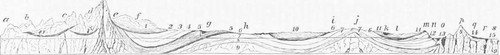
Fig. 4. - Great American Carboniferous and Tertiary Coal Formations. References: <i. Wasatch mts.; b, Green river; c, Sierra Madre; d, Rocky mts.; e, Denver; f, Black hills; g. the Missouri at Leavenworth; h, the Mississippi at St. Louis; i, Terre Haute; j, Cincinnati: k, Ohio river; l. Pittsburgh; m, suininit Alleghany mts.; n, Broad Top coal field; o, Pottsvillc; p, Blue Ridge (m, n, o,p, Appalachian mts.); q. Philadelphia; r, Richmond, Va. eoal basin; s, sea: t. t. sea level. - 1. tertiary coal; 1'. 1". tertiary coal formations; 2, cretaceous; 8, 4, trias and Permian; 5, great western coal field; 0, carboniferous limestone; 7, Devonian and Silurian; S, gneissic; 9, granitic; 10, central coal field; 11, Alleghany coal field; 12, Broad Top coal basin; also red shales, old red sandstone; also Bloonisburg, Towanda, &c; 13, anthracite coal basins; 14, new red sandstone; 15, Jurassic coal basins of Virginia and North Carolina.
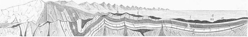
Fig. 5. - Appalachian Formations, Ancient and Modern.
References: Modern
A, the Atlantic sea; b, recent or cretaceous formations; c, granitic and volcanic; d. mesozoie, new red. etc.; e, mctamorphic, gneissic &c; g. sandstones and limestones of the valley, or the lower palaeozoic formations; A. slates and shales of the oil-producing formations; i, sandstones overlying the oil strata, including the old red and the conglomerate; .). the anthracite coal deposits; k, Cumberland coal field; l, l, n, Alleghany coal field; m, Ohio river.
The Potsdam sandstone underlies the Auroral limestone, g, and overlies the gneiss, e, which must exist to some extent in the entire basin. The dark vertical trap formations emerge from the granite, and were the means of forming the gneiss.
Ancient
No. 1 corresponds to a. and is the granite seacoast line, forming the volcanic boundary of the ancient sea; 2 is a deep view of the volcanic vent between the granite and the gneiss, which is formed of the vented matter: 8 is the metamorphic or early gneissic sedimentary rocks; 4 corresponds to g, and is the base of the palaeozoic; 5 is the bituminous slates of the oil strata, followed by the massive sandstones of the old red, and the subcarboniferous; 6 is the ancient sea, since filled by the sedimentary deposits represented in g, h, i.j. k l. etc.: 7. 7 is the line of volcanic vents existing in the plutonic or granite coast line, which extends from Maine to Cuba. The form of the ancient structure is of course ideal, and the two views are thus given together in order to convey an impression of the cause and its effects.
And The Place Of Coal Among The Rocks Table Of Sedimentary Strata
English Equivalents. | Pennsylvania. | Nomenclature. | Maximum and minimum thickness. | Missouri and Illinois. | Maximum and minimum thickness. | Maximum and minimum thickness. | REMARKS. | ||||
NEOZOIC. | Recent. | Drift, etc..... | ? | ? | Drift, etc.... | 150 | ? | ■ | |||
Tertiary... | Absent.. | Pennsylvania. | Penn. and N. York. | ? | Tertiary, no coal. | 200 | Tertiary coal.. | 250 to 1 500 | Containing lignite coal beds. | ||
Cretaceous... | Absent.. | ? | Absent.. | 0 | Cretaceous.... | 250 to 1,000 | Limestones and red sandstones. | ||||
Oolitic... | Absent.. | Absent.. | Absent..... | 0 | Oolitic.. | ? | Richmond, Va., coal. Not investigated in the west. | ||||
Triassic.. | Absent.. | Absent?.... | Absent..... | 0 | Triassic... | 300 to 500 | Containing gypsum, marls, etc, in Kan-sas and Colorado | ||||
Permian... | New red sandstone.. | New red sand-stone..... | Absent?.... | 0 | Permian.. | 1,000 to 1,500 | Magnesian limestone. | ||||
PALAEOZOIC. | Carboniferous. | Coal measures.. | Coal measures.. | XIII. | 500 to 3.000 | Absent.... | Coal measures.. | 500 to 600 | Coal measures .. | 1,000 to 3,000 | Concealed in Colorado by the tertiary. |
Millstone grit... | Conglomerate. .. | XII. | 100 to 1,500 | Absent.... | Millstone grit___ | 100 to 300 | Millstone grit | 10 to 100 | |||
Carboniferous limestones.. | Red shales.. | XI. | 0 to 2,000 | Absent .... | Carboniferous limestone... | 750 to 1,000 | Carboniferous limestones... | 150 to 750 | Occasionally seen in Colorado and Dakota. | ||
Sub-carboniferous | White sandstones. | X. | 200 to 2,000 | Gray and white sandstones.. | |||||||
Devonian. | Old red sandstone. | Red sandstones. | IX. | 0 to 5,000 | Catskill..... | Bituminous slates, shales, and limestones | |||||
Eifel....... | Limestones and shales... | VIII. | 1,000 to 7,000 | Chemung, Genesee, etc....... | 300 to 500 | Not seen..... | ? | Concealed or wanting in the far west. | |||
" .... | Bituminous black slates___ | VII. | 600 to 1,000 | Coniferous, Onondaga, etc.. | |||||||
Ludlow.. | Slates and sand-stones..... | VI. | 100 to 1,500 | Oriskany sand-stone, etc... | Oriskany.. | 0 to 50 | |||||
U. Silurian. | Wenlock..... | Marls, shales, and limestones. | V. | 1,000 to 4,000 | Saliferous, Niagars, etc... | Limestone... | |||||
Caradoc... | Medina sandstones.. | IV. | 200 to 2,500 | Medina sandstone, etc....... | Medina sandstone | 300 to 700? | Not seen... | ? | Concealed by tertiary in Colorado. | ||
Cambrian. | Bala rocks.... | Slates and lime-stones..... | III. | 500 to 2,500 | Slates and limestones ..... | Galena and magnesian limestones and calciferous sandstones... | 300 to 1,000 | Galena and magnesian limestone. | ? | Occasionally seen in Colorado and Dakota, but generally concealed by the tertiary, etc. | |
Festiniog group.. | Limestones... | II. | 1,000 to 6,000 | Limestones... | |||||||
Lingula flags... | Slates and Pots-dam sandstone. | I. | 1,000 to 4,000 | Calciferous Potsdam sandstone. | Potsdam sand- | 100 to 250 | Potsdam sandstone ...... | 50 to 250 | |||
Gneissic..... | Gneissic..... | 5,000 to 10,000 | Huronian gneissic | (Ozark) gneissic. . | 500 to 1,000 | (Rocky Mts.) gneis- | 5,000 to 10,000 | Metalliferous group of the Rocky mountains. |
Fig. 6.
A, or Alpha.
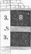
B, or Buck Mountain.
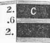
C, or Gamma.
Fig. 6, continued.
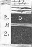
D, or Skidmore.
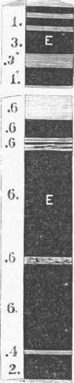
E, or Mammoth.
F, or Holmes.
G, or Primrose.
And Their Production Of Marketable Coal In 1871 Mining Districts Of The Alleghany Coal Field
Tons. | |
Frostburg coal district. Md........... | 2.156.576 |
Broad Top district Bedford co. Pa........ | 319,625 |
Towanda district, Bradford co. Pa........ | 393.023 |
Blossburg district, Tioga co., pa... | 819,848 |
Balston district. Lycoming co., Pa........ | 106,129 |
Snow Shoe district, Centre co., Pa.. | 62,468 |
Clearfield district. Clearfield co. Pa........ | 404.380 |
Cambria district, Cambria co., Pa... | 822,120 |
Monongaliela navigation district, western Pa... | 1,648,000 |
Alleghany river district, western Pa... | 969,000 |
Youghiogbeny river (including coke), western Pa. | 1,000,000 |
Line of Philadelphia and Erie railroad, Pa... | 120,000 |
Line of Pennsylvania railroad, chiefly gas coal, Pa. | 855,000 |
Block coal districts, western Pa... | 423.260 |
Other districts, estimated... | 1,000,000 |
Total in Pennsylvania... | 10,817,864 |
Baltimore and Ohio railroad, west Va... | 1S9.768 |
Kanawha district. West Va........... | 400.000 |
Eastern Ky., Ashland co., Ky.......... | 800,000 |
Ohio, entire state... | 5,000,000 |
Tennessee, entire state... | 250.000 |
Alabama, entire state... | 300,000 |
Total in Alleghany coal field... | 17,257,627 |
(In a few cases in this and following tables, the figures are approximated from data in the writer's possession, and include home consumption. The United States census, as shown on a subsequent page, indicates a smaller production, and was taken at an earlier date.) The respective areas occupied by this field in the several states which it traverses are exhibited in the following table:
AREA OF THE ALLEGHANY COAL FIELD. | |
Square miles. | |
Pennsylvania.. | 12,650 |
Maryland... | 470 |
West Virginia... | 15,000 |
East Virginia... | 225 |
Tennessee... | 8,700 |
Georgia... | 170 |
Alabama... | 4,500 |
Eastern Kentucky... | 10,000 |
Ohio...................... | 7,100 |
Total area ................... | 53,815 |
- The Central Coal Field. This extends through Indiana, Illinois, and Kentucky, embracing an area of 40,400 sq. m., of which 6,700 are in Indiana, 30,000 in Illinois, and 3,700 in western Kentucky. The deepest portions of this coal field contain the measures peculiar to the Alleghany coal field, from O to G inclusive. The latter has been unmistakably recognized on the waters of Green river in Muhlenberg co., Ky., and probably exists in the central portions of Illinois; but generally the lower barren measures are the upper rocks in this field in Indiana and Illinois; but the beds from O to E have a wide horizon. An attempt has been made by Prof. Owen and Lesquereux to identify the coal beds of this field with those of the Alleghany field, and a nomenclature embracing a series of beds from A to N has been adopted. The state geologist of Indiana, Prof. Cox, however, discards the nomenclature of Pennsylvania and all former geologists, because the known facts prove that the coal beds of Indiana cannot be divided into upper and lower measures:
TABLE OF COAL MEASURES IN INDIANA. | ||||||
Pennsylvania nomenclature. | Indiana nomenclature. | Coal beds. | Rocky strata. | REMARKS. | ||
ft. | in. | ft. | in. | |||
45 | 0 | Locality of the Mahoning sandstone. | ||||
F | N | 1 | 6 | This bed N in the Indiana nomenclature is, like its counterpart in Pennsylvania, rarely workable, while M is a mere streak. The rocks above L in this column are a part of the upper barren measures. | ||
31 | 0 | |||||
M | 6 | |||||
30 | 0 | |||||
E | T. | 5 | 0 | |||
14 | 0 | |||||
K | 5 | 0 | L and K of the group E are excellent and persistent beds, as usual. | |||
24 | 0 | |||||
D | J | 1 | 6 | The group C, which is always composed of very small beds, appears to be absent, though both Prof. Owen and Lesquereux give their equivalent. | ||
25 | 0 | |||||
B | T | 4 | 6 | |||
13 | 0 | |||||
H | 1 | 6 | I and 11 of the group B expand and contract, but one of them is always workable. | |||
25 | 0 | |||||
A | G | 4 | 0 | |||
24 | 0 | G and F of the group A are not regular, and seldom workable. They alternate from block to cannel coal. | ||||
F | 4 | 0 | ||||
263 | 0 | |||||
O | B | 2 | 0 | The millstone grit is here in regular order between the groups A and O. | ||
20 | 0 | |||||
A | 3 | 0 | The lower beds are rarely of merchantable quality. | |||
32 | 6 | 514 | 0 | 25 feet workable coal. | ||
This classification proves that no upper measures exist in Indiana; consequently, the attempt to identify them could not fail to be delusive. The character both of the coal and the coal beds proves their identity, however, with the grouping herein given, while the thickness of the strata corresponds with the lower measures, and cannot include the upper. The absence of C, D, E in Prof. Cox's nomenclature is accounted for by the fact that they represent mere local streaks of coal. In the anthracite measures, and also in the Alleghany field, these small local seams are often met with; but having no regular horizon, they are not recognized in geological sections. In the numerous sections given by Prof. Cox the distance between his I and K varies from 20 to 90 ft.; this space is generally large, showing a well marked horizon, in which the micaceous sandstone is noted by most observers in that field. At the Mt. Carbon coal mines in Jackson co., 111., the micaceous standstone over the group B is very distinctly defined, and the double character of the bed is unmistakable. At the mines this group forms a single bed, 5 ft. thick, with from 1 to 3 in. of fire clay as a parting; but in less than half a mile to the southeast these beds are parted by 20 ft. of fire clay.
Generally, one of these expands while the other contracts in thickness, and they are seldom of equal size. If the upper one diminishes the lower increases, and vice versa. There can therefore be no doubt of the identity of the block coal bed I of the Indiana nomenclature with the group B of the Alleghany coal field, which produces the same class of coal in many parts of Pennsylvania, Ohio, West Virginia, and Kentucky. The identity of the measures and the coal groups A and O, which are generally block or cannel below B, is manifest, and there can scarcely be a doubt in regard to the fact that the upper coal beds in Indiana are all in the lower coal measures, and beneath the Mahoning sandstone. It is true that the coal measures decrease in thickness in many localities, and generally in a westward direction. The general thickness of the strata in Pennsylvania between B and G is from 600 to 1,000 ft.; but at Scranton, in the north or Wyoming anthracite field, the distance between these beds is only 200 ft., and on the eastern edge of the Alleghany coal field, in the small coal basin of Sullivan co., Pa., the distance from the conglomerate to the group E, which here forms a single bed 11 ft. thick, is only 130 ft., though the usual distance is from 200 to 500 ft.
In western Kentucky the coal measures are of the usual thickness. In this part of the central coal field the distance between B and G is 800 ft. The identity of these beds is unmistakable. The lithological structure and character of the accompanying strata, their own stratigraphic-al structure, their features and fracture and chemical composition, as well as the palaeon-tological evidences, prove this identity beyond doubt. As this is a question of much importance in American geology, an exact designation is desirable. It may be stated that the bed mined by Gen. Don Carlos Buell at Air-drie, Ky., on the Green river, is the Pittsburgh or G coal bed, the character of which is excellent, and similar to that of its more celebrated counterpart of Pennsylvania. The bed B is found some 10 miles further up the Green river, cropping out in the Muddy branch, and is about 4 ft. in thickness of excellent satin-black block coal, which has been thoroughly tested in the blast furnaces of Carondelet, Mo., and pronounced an excellent furnace fuel. Much the larger portion of the coal lies below the water level in the central field, and most of the mining is done by shafting, and is at present almost exclusively confined to the margins of the field.
This is owing principally to the fact that the lower barren measures cover and conceal the beds to a great depth in its more central portions. If the great bed G existed to any considerable extent, it would have been developed in many localities on the higher ground toward the centre of the field. A circle of pits and mines almost surrounds this field. Commencing at Iron City on the Ohio, in the Indiana block coal district, or outcrop of bed B, it extends almost directly N. to Brazil, from thence curves N. W. to Danville or Mil-ford, Gilman, and La Salle in Illinois, and from thence W. to Rock Island; thence down the Mississippi, in an irregular line, some distance east of the river to Alton and Bellville; thence to the Mt. Carbon mines .on the Big Muddy, Duquoin on the Illinois Central railroad, and Shawneetown on the Ohio, below Evansville. Here the bed crosses the river into Kentucky, and, making a half circle in that state, again crosses the river to the point of starting at Iron City. The coal is mined in many localities around this entire circle. About 1,500 miners were at work during 1872 in the block coal districts, producing more than 6,000 tons of coal a day, or over 1,500,000 tons a year.
Much of this coal is used in the blast furnaces which have recently been erected near Brazil; and large shipments are made to Chicago, St. Louis, and many of the surrounding towns and cities. Both at La Salle and Rock Island extensive mining operations are conducted; while opposite St. Louis and at Mt. Carbon the coal mines are still more productive. The coal production of Illinois is now more than 2,000,000 tons per annum. A very large increase in the production of the central field in Indiana and Illinois has taken place since 1870; but the amount mined in western Kentucky is still quite limited, and does not exceed 150,000 tons per annum. The total production of the central field in 1872 was between 3,500,000 and 4.000,000 tons. - The great Western Coal Fiehl. This, though but little developed, is the largest coal field in the world. A few years ago it was not recognized on our geological maps except as a portion of the central field, and its immense extent was not suspected. Even now eminent geologists affirm that no true coal exists west of the Missouri river; and Prof. Owen pronounced the rocks on the banks of the Missouri in Kansas subcarbonife-rous; yet the outcrops of this immense coal field have been developed in numerous localities through the entire states of Iowa and Missouri, into southern Kansas, western Arkansas, and the Indian territory.
The strata undulate in a few localities around the eastern outcrops of this immense field; but generally the dip of the strata is uniformly westward, with a declination of from 5 to 10 ft. per mile. The carboniferous limestone contains numerous pockets of the lower group O in Missouri, some of which are of great thickness. The coal is a grade between block and cannel, and contains a large proportion of oxygen, water, and sulphur. In northern Missouri and Iowa these pockets have not been found, but in Arkansas the lower group O contains all the available coal in that portion of the field. The millstone grit, the groups A and B, and the micaceous sandstone exist in regular and uniform order in both Missouri and Iowa. It is not positively asserted that this coal field is identical with the Appalachian formations, though the developed facts seem to indicate this relation as far as the lower groups O, A, and B are concerned. But above the micaceous sandstone nothing of a definite character has been developed, beyond a few thin beds of coal, and immense congeries of massive limestones and shales, with a few thin and changeable sandstones, which vary from the silicious to the calcareous, in the upper portions of the coal measures.
Interstratified with the shales and limestones are numerous beds of bituminous shale, which seem to take the place of many of the coal beds of the more eastern formation. The peculiar shales, which are composed of arenaceous, argillaceous, and calcareous material, and known as soapstone by the miners, exist in nurses from 20 to 50 ft. in thickness. These seem to be a sediment of mud, and occupy the place of the coarser shales of the east. They disintegrate when exposed to the atmosphere, and their outcrops are always marked by the dark soils which they produce. Such sandstones as exist are also soft and friable when exposed on the surface. Numerous beds of fire clay and a few quicksands are found, both of which disintegrate rapidly in contact with water. All the rocks of the lower portion of these coal measures, except the limestones, are soft and disintegrate on the surface. Of all the rocks mined from a shaft 750 ft. deep at Leavenworth, none stood exposure to the atmosphere except the limestones and a few very thin plates of calcareous silicates. There is an almost entire absence of the cementing or hardening principle found in the more eastern rocks, which appear to owe their hardness and homogeneous texture to the presence of liquid silicates during their formation.
The limestones, however, are an exception to this rule in the coal measures. They are hard, close-grained, or homogeneous, both east and west; but in the cretaceous formations they also lose their hardening element. It would thus appear that the hardness or induration of the rocks is not wholly due to mechanical force or pressure, because the stratified sedimentary material frequently exists in a soft and pulverulent condition even at great depths; and the example of the measures in the great western coal field is one of the most conclusive. Numerous attempts have been made to penetrate these measures by the drill; but owing to the quicksands and soft decomposing fire clays and shales, none have succeeded in penetrating to any considerable depth without the use of tubing. There is no evidence that a high temperature ever existed in this field, or that the fluid silicates had any influence in hardening the rocks, with the exception of the limestones, the millstone grit, and perhaps some of the thin lower sandstones. It seems evident therefore that the hardness of the rocks is due more to chemical action than to mechanical force or pressure.
As before remarked, there is a constant decrease of the sandstones and coarse shales westward, from the outcrops of the palasozoic strata on the eastern escarpments of the Alleghanies to the Rocky mountains, and a diminution in the size and number of the coal beds; but there seems to be but little decrease in the actual thickness of the coal measures, the limestones making up the deficiency of the sandstones and shales. These limestones contain no fossil flora except a few fucoids, but generally an abundance of marine fossils of animal life; while the sandstones, even in the deep Kansas basins, contain numerous remains of fossil flora, broken and scattered, and but few fossiliferous animal organisms. The fossil plants, as far as developed, are chiefly calamites and fucoids, which have left only a dark carbonaceous impression, without any solid substance. In the 2,000 ft. of coal measures in Kansas from 20 to 30 beds of coal exist, from one inch to 7 ft. in thickness, and 80 distinct beds of limestone. In the Leavenworth shaft, which is 750 ft. deep, and which seems to penetrate the lower measures, the pit is barren of coal to a depth of 000 ft., and the rocks for 200 ft. above it contain no workable coal beds.
But some of the bituminous shales are known to produce an impure block or splint coal in other districts, and some of the coal seams, which are mere streaks in one locality, or entirely absent, expand to workable dimensions in another. But it is extremely difficult if not impossible to identify either the coal beds or the rocky strata over any great extent of country. The fossils of the western coal field are numerous, but they are confined to no regular horizons, and the silicious rocks are frequently changed to the calcareous; or in one locality the silicious element predominates, while in another the calcareous is in excess in the same strata. No correct section of the measures of this field can be given at present, except that portion penetrated by the Leavenworth pit, which does not conform in any manner with the geological sections of the Kansas survey, but agrees to some extent with those of the Missouri surveys.
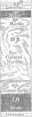
Fig. 7. - Leaven-worth (Kansas) Marble.
SECTION OF LEAVENWORTH PIT. | ||
ft. | in. | |
Soil...................... | 11 | 0 |
Slaty sandstone................ | 7 | 6 |
Limestone, hard................ | 14 | 0 |
Bituminous shale............... | 4 | 6 |
Blue limestone................. | 1 | 6 |
Shale (soapstone)................ | 23 | 0 |
Hydraulic limestone................ | 14 | 0 |
Calcareous slate................. | 8 | 0 |
Shale (blue and purple soapstone)......... | 25 | 0 |
Gray limestone.................. | 8 | 6 |
Black slate................... | 6 | |
Shale, soapstone.................. | 54 | 0 |
Limestone.................... | 13 | 0 |
Bitum inous shale................ | 4 | 0 |
Limestone.................... | 5 | 0 |
Slate....................... | 1 | 6 |
Rich bituminous shale.............. | 2 | 6 |
Fire clay.................... | 4 | |
Limestone.................... | 1 | 0 |
Bituminous shale................ | 7 | 6 |
Limestone.................... | 5 | 0 |
Slate ............................ | 1 | 6 |
Limestone.................... | 7 | 0 |
Shale (soapstone)................ | 22 | 0 |
Limestone.................... | 4 | 0 |
Shale (soapstone)................ | 57 | 6 |
Limestone.................... | 3 | 6 |
Black shale................... | 5 | 6 |
Limestone.................... | 30 | 0 |
Slaty limestone................. | 5 | 0 |
Limestone.................... | 5 | 0 |
Black shale................... | 2 | 0 |
Dolomitic marble (very fine; see fig. 7)..... | 16 | 0 |
Shales (soft).................. | 3 | 0 |
Limestone.................... | 12 | 0 |
Shale (soapstone)................ | 136 | 0 |
Limestone.................... | 6 | 0 |
Shale (soapstone)................ | 36 | 0 |
Limestone (silicious).............. | 2 | 0 |
Fire clay.................... | 2 | 0 |
Rich bituminous shale (sometimes coal)...... | 1 | 0 |
Limestone (silicious).............. | 2 | 0 |
Shales (soapstone)................ | 10 | 0 |
Hard limestone.................. | 4 | 0 |
Shales and thin sandstones............ | 25 | 0 |
Rich bituminous shale (cannel shale)....... | 2 | 6 |
Sandstones and shale (thin)........... | 11 | 6 |
Hard limestones................. | 4 | 6 |
Fireclay..................... | 1 | 6 |
Slate....................... | 7 | 0 |
Sandstone.................... | 2 | 0 |
Black slate................... | 5 | 6 |
Coal, impure................... | 1 | 0 |
Sandstone and slate mixed............ | 6 | 6 |
Limestone.................... | 3 | 0 |
Black slate................... | 1 | 0 |
Fire clay.................... | 1 | 6 |
Sand, slate, and limestone (thin)........ | 4 | 6 |
Black slate................... | 1 | 0 |
Coal and slate.................. | 6 | |
Fire clay and slate.............. | 4 | 0 |
Fire clay, sand and lime mixed, quicksand.... | 8 | 0 |
Hard limestone with some pyrites......... | 9 | |
Fire day and slate (soft)............ | 12 | 6 |
Micaceous sandstone............... | 6 | 4 |
Sandy slate and clay (shale)........... | 6 | 10 |
Black marble (Fort Scott'!)........... | 4 | |
Black slate................... | 3 | 8 |
Coal (good)................... | 1 | 1 |
Black slate (carbonaceous)............ | 4 | 0 |
Sandstone.................... | 2 | 0 |
Black slate (carbonaceous)............ | 9 | 2 |
Micaceous sandstone............... | 8 | 8 |
Bandy slate (black)............... | 16 | 6 |
( Black slate (fine)............... | 1 | 5 |
(Coal (trood), 20 to 30 inches......... | 2 | 0 |
Fire clay...... ............ | 1 | 8 |
Total | 750 | ft. |
Above the top of the Leavenworth pit from 800 to 1,000 ft. of coal measures exist, in which there are two and sometimes three coal beds, which occasionally expand to workable size, from 20 to 30 inches, and several smaller seams. The character of the strata is much the same, but in the lower portion of the measures the sandstones predominate, as shown in the foregoing section. The Boonville, Mo., bed B, which is persistent through Iowa, Missouri, southern Kansas, and the Indian territory, is supposed to exist below the point penetrated by the Leavenworth pit. Seven coal beds, varying from 1 to 7 ft., are found above the millstone grit, and in the southern part of the field two beds varying from 10 in. to 4 ft. exist below it. The total amount of workable coal varies from 20 to 30 ft., including the group O, and some of the richer bituminous shales, which often change to merchantable coal. It will be noticed that these are frequently accompanied by the usual black slate and fire clays of the regular coal beds; and it may reasonably be inferred that these rich shales, or more properly schistose coals, occupy the place of the purer coal of other fields.
The great amount of carbonic acid absorbed by the limestone, and the condensation of the hydrocarbons or bitumen in the shale, would account for the limited amount of coal and the meagre character of the beds; while the low temperature which evidently prevailed, and the absence of a numerous fossil flora, may be advanced as the cause of this change in the character of the coal measures, as compared with the Appalachian fields. A very limited portion, however, of this great coal field is exposed, perhaps not over 130,000 sq. m., and still less have been explored in Nebraska, Kansas, Iowa, Missouri, Arkansas, and the Indian territory, while much the larger area is covered and concealed by the overlying Permian, triassic, cretaceous, and tertiary rocks, from 3,000 to 5,000 ft. of which are piled on the coal measures, Their order and thickness are given in the Colorado and Kansas column in the accompanying table of sedimentary rocks. The western outcrops of the carboniferous rocks have been found along the eastern base of the Rocky mountains and the Black hills of Wyoming and Dakota; but the Permian and other more recent formations repose on the carboniferous strata in an unconformable manner, and their outcrops are only exposed where the tertiary and other unconformable rocks have been removed by denudations.
But none of the carboniferous coal beds have yet been discovered on the western outcrops of this field. It may be presumed, however, that the coal measures and their accompanying beds of coal underlie the entire area covered by these rocks east of the Rocky mountains, and the Black hills in Dakota, Nebraska, and Colorado. It is a well known geological fact that the coal measures and all sedimentary strata were deposited in basins, and all basins must have reverse dips, which experience confirms. Consequently this great coal field occupies an area both outside and beneath the Permian and other more recent formations of very great extent, as shown by the following table:
AREA OF THE GREAT WESTERN COAL FIELDS. | |
Sq. m. | |
Dakota, outside of the cretaceous?......... | 20,000 |
Iowa (carboniferous)............... | 24,000 |
Missouri, " ............ | 21,000 |
Kansas, outside of the Permian.......... | 17,000 |
Arkansas, " " " .... | 12,000 |
Ind. Ter. " " " .......... | 20,000? |
Texas, " " " ............. | 20,000? |
Total................... | 184,000 |
Dakota, covered by the more recent formations.. | 40,000? |
Nebraska, " " " ".. | 60,000 |
Kansas, " " " " .. | 63,000 |
Ind. Territory, " " " ".. | 40,000? |
Texas, " " " ".. | 80,000? |
Total................... | 233,000 |
Totalarea... | 867,000? |
- The southern coal field, in Arkansas, is a continuation of the group O, or the sub-conglomerate coal of the western coal field. The two beds of this group extend eastward on the low banks of the Arkansas river. The lower bed varies from 2 to 5 ft. in thickness, and the upper one from 10 in. to 2 ft. As usual in Kentucky, and other parts of the central coal field, the upper portion of the upper bed is a soft carbonaceous shale, and 3 ft. of the lower portion only produces workable coal. These beds are covered with an unusual accumulation of unproductive strata, including the millstone grit, which is apparently duo to the influence of the Ozark range of volcanic mountains in this vicinity. These rocks are devoid of fossils except near the coal. The coal fields of Australia are similar to this extension of the western field in Arkansas, and geologists have noted the fact that there the coal exists exclusively beneath the millstone grit. This extension of 12,000 sq. m. is included in the western coal field. The northern or Michigan coal field, 12,000 to 13,000 sq. m. in extent, is similar to the central coal field, and may be considered part of the same. It contains the groups A and B exclusively. The group O has not been noted in this field.
The amount of coal mined in this and the preceding field is limited; only a few tons for local consumption are mined in the former, and not 250,000 tons per annum in the latter. - The Tertiary Coal Fields of the United States are scarcely less extensive than the western field. Fully 50,000 sq. m. of this formation have been identified and partially developed; while it is estimated that no less than 250,000 sq. m. exist in the United States and the British possessions. They include a large area within the western coal field in Kansas, Colorado, and Dakota, but a much larger one is found outside of its limits in Wyoming, Montana, and Saskatchewan (British America), while numerous detached basins or fields are found in Colorado, New Mexico, Texas, California, Oregon, and Washington. But some of the latter are more strictly lignite than the true tertiary coals of the Rocky mountain range, which are stratified with massive sandstones, shales, slates, and clays, as uniformly as the coal measures of the carboniferous formations, while the coal beds are equally as large, and the coal nearly if not fully as pure; but it contains a much larger percentage of oxygen and water than those which are denominated true coals.
These so called lignites may, however, be as strictly termed true coals of the oxygenated class, as the famous block coal of the central or Alleghany fields. But as they contain a large percentage of water, which exerts an injurious influence on their combustion, they may be more properly denominated hydrated coal. The term lignite is a misnomer, because they contain no more lignine than the coals of the carboniferous rocks. The true lignites are the brown or wood coal, which exist in the clays of the upper tertiary formation, and beneath the alluvium or drift, and are rarely ever in sandstone or rocky strata. There are, however, more impure coals or beds of bituminous substances in the tertiary than in the carboniferous rocks. It is not yet possible to designate all the localities of the tertiary coals in the United States, or to separate the pure from the impure; but as far as present developments indicate, the great regions of these tertiary formations are parallel with the Rocky mountain ranges.
Immense beds are found along the Union Pacific railroad in Wyoming territory, and from Cheyenne, on this road, along the eastern base of the mountains, through Colorado, New Mexico, and Texas, while they extend eastward into Kansas. The present most productive mines are at Carbon, Rock Springs, and Almy stations (Evanston mines), on the Union Pacific railroad, and at Boulder City, Central City, and Cafion City, Colorado; and this formation is supposed to exist, with its coals, both east and west of the Black hills of Wyoming, and those of Dakota (which are distinct mountains east of the Rocky mountains), extending in parallel ranges into Dakota on the east and Montana on the west of these mountains, and continuing into the British possessions. The more western tertiary exist along the coast ranges in California, Oregon, and Washington. The prominent localities where coal is now mined are at Bellingham, Washington territory, Vancouver's island, Coos bay in Oregon, on the Columbia river, and near San Francisco at Mt. Diablo. There are many other localities in California, Oregon, and Washington where small deposits are found; in many cases these constitute only part of more extensive formations which cannot yet be distinctly defined.
The following analysis of these coals made by Henry M. Smith, mining engineer, and published in the "Engineering and Mining Journal" of New York, is the best that has yet appeared; and although it does not embrace the more excellent coals of the Evanston, Boulder City, or Canon City mines, it is expressive of the character of this class of coals:
ANALYTICAL TABLE OF THE FAR WEST TERTIARY COALS. | |||||||||
LIGNITES. | Carbon. | Hydrogen. | Nitrogen. | Oxygen. | Total sulphur. | Sulphur as sulphurine acid. | Water. | Mineral matter.* | Color of ash. |
1. Mount Diablo, California... | 59.724 | 5.078 | 1.008 | 15.697 | 3.916 | 0.107 | 8.940 | 5.637 | Dark red. |
2. Weber river. Utah...... | 64.842 | 4.336 | 1.288 | 15518 | 1.002 | Trace. | 9.415 | 2.999 | White. |
3. Echo canon. Utah...... | 69.840 | 3.897 | 1.932 | 10.990 | .708 | 0.015 | 9.170 | 3.403 | Gray. |
4. Carbon station, Wyoming... | 64.992 | 3.762 | 1.736 | 15.199 | 1.066 | 0025 | 11.505 | 1.680 | Yellow brown. |
5. Carbon station, Wyoming... | 69.144 | 4.362 | 1.246 | 9.539 | 1025 | 0.049 | 8.005 | 6.619 | Pink. |
6. Coos bay, Oregon...... | 56.244 | 3.379 | .420 | 21.815 | .810 | 0.095 | 13.285 | 4.047 | Dark brown. |
7. Alaska........... | 3.264 | .608 | 19.004 | •632 | None. | 16.520 | 4.183 | Ochre. | |
8.Alaska............ | 67 674 | 4.658 | 1.582 | 12804 | •920 | None. | 3.075 | 9.287 | Pinkish. |
LIGNITIC ANTHRACITES. | |||||||||
9. Santa Fe, New Mexico.... | 74.372 | 2.583 | 1.704 | 8.712 | •727 | Trace. | 3.190 | 6.052 | Pink. |
10. Les Brouces, Sonora.... | 84.103 | •852 | .280 | 2.137 | •229 | Trace. | 5.195 | 7.204 | Gray. |
The excessive amount of water which this class of coals contains will be noticeable; but the Rocky mountain coals, 2, 3, 4, and 5, contain no more ash than ordinary coals; and as the best varieties are omitted in this table, it is evident that these are true coals. The water, however, is an obstacle to their use in the solid condition as fuel. They decrepitate under heat or in exposure to atmospheric influences, and consequently cannot be used in the blast furnace; while it is exceedingly difficult to coke any coal deficient in hydrogen or which contains oxygen in excess. The water which they contain, however, is not greater than that of the New England anthracite. In order to utilize this class of coals effectively, it will be necessary to reduce them to the gaseous condition, and use the gas instead of the solid coal as fuel. The great bed mined at Evanston, Wyoming, known as the Mammoth, is 48 ft. thick and stratified as shown in the accompanying figure. Chinese labor is employed exclusively in the Evanston mines, with satisfactory results, though they produce more slack or refuse coal than the English or Welsh miners. The amount of coal produced is about 100,000 tons per annum, and the same amount is mined at Rock Spring and Carbon station.
The entire production of the so called lignite coals in the far west now approaches 500,000 tons per annum. The Boulder City coal formation seems to include the entire tertiary coal measures, embracing 11 coal beds in 1,500 ft. of regularly stratified clays, slates, shales, and sandstones. These beds range from 4 to 20 ft. in thickness. An analysis of the Boulder and Coal creek coals, as given by Prof. Hayden, United States geologist, is as follows:
* Ash minus oxygen absorbed by the iron of the pyrites.
Carbon. | Volatile matter. | Water. | Ash. | |
Boulder City... | 59.20 | 26.00 | 12.00 | 2.80 |
Coal creek.. | 5S.70 | 19.30 | 20.00 | 2.00 |
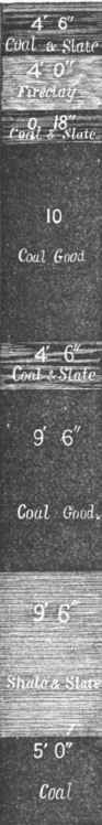
Fig 8. - Tertiary Mammoth Coal Bed. Ev. anston, Wyoming Territory.
The fossil plants of these coal formations are similar to those of the lower tertiary rocks of Europe, and the lower tertiary formations of the United States generally. These coals have frequently been referred to the cretaceous, but they are clearly of the great tertiary coal period, which was scarcely less productive of coal than the carboniferous epoch, as the immense tertiary formations of the Rocky mountains, the Sierra Madre, and the Andes in America, and the Hindoo Koosh, Himalaya, and other great mountain ranges in Asia. The fact that the western edges of the palaeozoic strata, outcropping along the eastern base of the Rocky mountains, are covered in an unconformable manner by the tertiary, is sufficient evidence that the former strata were tilted by the upheaval of these mountains after its deposition and before the formation of the tertiary. It is also evident that some influence must have acted to decrease the coal production in the carboniferous rocks of the west, and yet increase it in the tertiary. It is inferred that this influence is increased or decreased temperature; and tliis deduction is clearly sound and logical.
Consequently the Rocky mountains could scarcely have had any existence during the deposition of the palaeozoic rocks, and volcanic action was not then and there frequent. It is shown that plutonio heat, or the radiated heat of the original igneous crust of the earth, had no influence in producing coal, because these rocks are most remote in the anthracite regions of Pennsylvania and most proximate to the carboniferous coal of the west; nor had they much if any influence in producing the crystalline or highly indurated rocks, as the facts clearly demonstrate. "We are therefore driven to the conclusion that volcanic heat is the influence most potent in these productions. The most energetic period of volcanic action in the west was consequently during the tertiary period, after the carboniferous, Permian, triassic, and cretaceous rocks had been deposited in the deep basins of the western coal field, and long after volcanic action and the production of coal strata had ceased in the Alleghany and central coal fields; also since the production of the Jurassic coals in the Richmond, Ya., and North Carolina coal fields in the east. We may justly conclude that the atmospheric influences had changed to a considerable extent during this late production of coal.
Indeed, we find numerous fossil plants in the tertiary coal which are closely allied to living families. It seems to be a fact, though only recognized in geology at a late day, that the precious metals, if not the great body of iron, copper, and many other metalliferous deposits, are creations of a comparatively late period; while the present volcanoes, the geysers, and the earthquakes of the far west, all point to the central facts that coal is largely produced by the influences of volcanic heat, and that the great tertiary coal fields of the far west are due to these influences. They are true coal fields, and their coals were produced in the same manner as those of the carboniferous epoch, under the influence of a cooler atmosphere, but from the same combinations of carbon, hydrogen, oxygen, and nitrogen, through organic or more direct chemical agencies, whether the mineral or petroleum theory obtain. - The Jurassic Coal Fields of Virginia and North Carolina, more strictly referred to the lias, are intermediate formations between the carboniferous and the tertiary, in comparison with either of which these are exceedingly limited and imperfect. The Richmond field, which is about 80 sq. m. in area, is supposed to have been formed in the crater of an extinct volcano.
The porphyritic, sye. nitic, and trap rocks of this field indicate the origin. In the centre of the field a single bed, ranging from 8 to GO ft. in thickness, rests frequently on porphyry, but more commonly on a deposit of granitoid mud or shale. Peaks of granite pierce this field in cone.like or irregular anticlinals in many places; they rise occasionally to the surface, but oftener they occupy low anticlinals, known to the Virginia miners as "troubles,"' around the base of which the coal bed assumes its largest proportions. On or near the top the coal thins to a mere streak, and sometimes disappears entirely; and this peculiarity is more marked in some localities than in others. In the Deep Run, or north. astern basin, these cones and ridges of granite cut this portion of the field into many small cup-like basins. At the northern extremity the basins appear to be more regular, but the coal is divided into five beds, of 3 to 7 ft. in thickness. The three lower beds are bituminous coal of the hydrogenated variety, containing a large proportion of earthy matter, sulphur, and water. The fourth bed is a natural coke, produced by an intrusion of trap GO ft. above it, and 20 ft. below the fifth bed, which is reduced to a graphitic or dark earthy cinder, resembling scoria.
Many suppose that anthracite is a metamorphic coal, changed from the common bituminous coal by heat of this character; but neither this nor any other example confirms such a theory. In the western part of the field, where developed, the coal bed is again single, and from 7 to 12 ft. thick. In this part the dip is very irregular; it frequently changes from the horizontal to the perpendicular, in steps, little or no coal being found where it is vertical; but this is compensated for by a great increase of coal on the fiat benches. The deepest portion of the basins yet reached is nearly 1,000 ft. by the Midlothian pit, which is the deepest coal pit yet sunk in the United States, though there are now (1873) two in progress near Pottsville, Pa., which are intended to penetrate 1,500 ft. This was the first coal field developed in the United States, as trees considerably over 100 years old were found growing on banks of waste coal in 1857. During 1770-'75 this coal was used extensively on the James river, and at the Westham foundery to manufacture shot and shell during the revolution, until destroyed by Benedict Arnold in 1781. The export trade to Philadelphia, New York, and Boston was considerable during 1789 and up to 1845; but recently this trade is entirely local, and struggles hard to compete with other coals in the home market.
The present production is very small. The mining operations in this field have generally been of a rude and primitive character, and confined to small ventures; but there have been a few costly enterprises, and nearly as many serious failures. This coal formation, deposited on an irregular granite or volcanic basin, is always uncertain; the surface presents little or no indication, and no preliminary investigation is really sure, except that which is done by the drill. In the deep pits of Midlothian, and also those of Clover Hill, in the southern portion of the field, the mine gases are produced abundantly, and several serious and fatal explosions have occurred. The Deep river coal field in North Carolina, which is about 100 sq. m. in area, is another Jurassic coal field of much the same character as the Richmond field; but it is deposited on immense sandstone strata, which, according to Prof. Emmons, are from 2,000 to 3,000 ft. thick. These form a more regular floor on the gneissic rocks than would have otherwise existed; but the evidences of volcanic heat are everywhere manifested, in the red and often altered character of the sandstone, and the anthracite nature of a portion of the lower coal beds, while the remainder is bituminous, of the hydrogenated class, but generally earthy and sulphurous.
There are six beds of coal in this field, from 6 in. to 6 ft. thick, in 1,000 ft. of coal measures, which is covered by a great thickness of barren, sandy strata. The depth of the basins is unknown. A shaft has been sunk 360 ft. at Haywood, but the production of coal is yet very limited. A great impetus to the development is expected from the railroads in progress. The Danville, pr Piedmont, which is the third of these southern or Jurassic coal fields, extends from a point near Willis's mountain, in Cumberland co., Va., to Ger-mantown, N. C, via Farmville and Danville. It is very narrow, plicated, irregular, and often interrupted, and is deposited in a series of narrow, canoe-like triangles in the gneissic rocks. The floor of the coal measures is a heavy, brownish, coarse sandstone, often massive, but much disrupted with trap dikes, and considerably altered by heat. The lower beds are in some places anthracite or graphitic in character, and a portion of the upper beds, near the trappean overflows or dikes, is a natural coke.
It is difficult to ascertain the area of this coal formation in its present state of development, which is limited to a few openings for local consumption, but it is estimated to contain 20 sq. m. in Virginia and the same in North Carolina. There are nine seams or beds of coal, from 6 in. to 3 ft. thick, in from 500 to 900 ft. of measures. It is similar to the Deep river coal field in character, though the beds are much smaller. The chief value of those Jurassic coals will be for local consumption, or the production of carbonic oxide gas as a fuel. There is clear evidence of volcanic agencies in the production both of the rocky strata and the coal in these southern coal fields; but a large portion of the coarser sandstones and shales evidently originated from detrital sources, which is quite possible in a field situated on the edge of a great ocean, and over which the waves of the Atlantic may have rolled even during its formation. That which is impossible in the wide Appalachian fields is here both possible and probable, but only to a limited and local extent. - The anthracite coal fields of Pennsylvania, Virginia, and the New England states are treated in the article Anthracite. - The Acadian Coal Fields. These fields, in the British provinces of Nova Scotia, New Brunswick, Cape Breton, and Newfoundland, have been variously estimated to contain from 5,000 to 10,000 sq. m., but a very large portion of this area contains no workable coal.
The coal measures of this region are of immense thickness, and may be divided as follows:
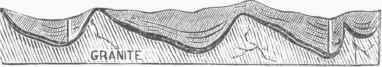
Fig. 9. - Transverse Section, Richmond Coal Field.
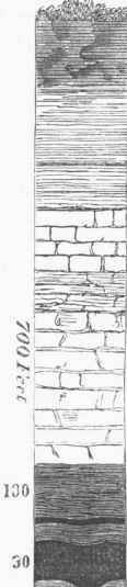
FlG. 10. - Vertical Section, S. side of Richmond Coal Field.
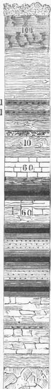
FlG. 11. - Vortical Section. N. side of Richmond Coal Field.
ACADIAN COAL MEASURES. | |||
SYSTEMS. | Thickness. | COAL BEDS. | |
No. | Thickness. | ||
First......... | 2.267 ft. | 8 | 94 ft. 0in. |
Second..... | 2,134 " | 22 | 5 " 5 " |
Third......... | 2.534 " | 47 | 47 " 9 1/2 " |
Fourth........ | 2.802 " | " | ..... |
Fifth.......... | 3,240 " | 9 | 0 " 10 " |
Total...... | 12,977 ft. | 86 | 148 ft. 0 1/2in. |
The upper measures contain nearly all the available or workable coal, and these are confined to the eastern point of Nova Scotia and Cape Breton island, and a limited area in close proximity to the gneissic rocks on the southern edge of the coal field; 2,200 sq. m. is the limit of productive coal area. The productive coal beds exist in 668 feet of measures. Their names and dimensions are as follows:
PRODUCTIVE ACADIAN COAL BEDS. | |
No. 1. Main coal, upper bed......... | 36 ft. |
2. Deep coal.............. | 22 " |
" 3. Third coal.............. | 4 " |
" 4. Purvis coal......... .... | 4 " |
" 5. Flemming coal........... | 4 " |
" 6. McGregor coal... | 6 " |
" 7. Oil coal............... | 4 " |
" 8. Second oil coal........... | (?) |
Total thickness......... | 80 ft. |
These seams, however, are confined to an area of 350 sq. m., and are known as the Pictou coal region. The Sydney coal fields, or those of Cape Breton, are much more limited, in size. The beds are four in number, and range from 3 to 6 ft., or 18 ft. in total thickness. The coal is of the hydrogenous class, though some of the Pictou coals tend to the splint order in structure. Most of these coals decompose in the atmosphere, and ignite spontaneously. The coal production in 1871 was about 625,000 tons. - The foregoing embrace all the American coal fields, with the exception of some uncertain formations in Greenland, the British possessions, the arctic region, and Alaska, and a few limited deposits of tertiary coals in Mexico and South America. Mines are opened at Panama and at Lota, which produce 100,000 tons per annum, Lotella and Co-ronel in Chili, and recently in Brazil. The total production of all the coal deposits south of the United States does not exceed 500,000 tons per annum.
AREA OF COAL FORMATIONS IN THE U. STATES. | |
LOCALITIES. | Sq. m. |
New England anthracite field, in Vermont and Maschussets... | 500 |
Pennsylvania anthracite fields........... | 470 |
Southern Jurassic coal fields........... | 220 |
Alleghany coal field............... | 53,895 |
Central coal field................. | 40,400 |
Northern coal field................ | 13,000 |
Western coal field (outside of the Permian).... | 134,000 |
Rocky mountain and far west tertiary coals.... | 50,000 |
291,485 | |
Rocky Mt. and western tertiary coals undeveloped., | . 100,000? |
Western coal field (under Permian and tertiary).. | , 233,000? |
Total in the United States........., | 624.485 |
Tertiary coals in the British possessions.'..... | . 100.000? |
Acadian (British coal fields)............ | 9,000 |
Other coal fields in South America (estimated)... | 5,000 |
Total area of American coal fields..... | 738.4S5 |
PRODUCTION OF AMERICAN COALS IN 1872. | |
Tons. | |
Pennsylvania anthracite, official......... | 18.929.263 |
" " local consumption. ....... | 3.110,000 |
Alleghany coal field, Pennsylvania...... | 10,817,864 |
" other 'states........ | 0.439,7(13 |
Central coal field........ | 4.000,000 |
Western coal field................ | 250,000 |
Far western tertiary coal............ | 500,000 |
Total production in United States... | 44,150.263 |
Acadian coals in Nova Scotia and Cape Breton.. | 768.000 |
South America tertiary coals (estimated)..... | 500,000 |
Total American production... | 45,424,263 |
AREA OF THE PRINCIPAL PRODUCTIVE COAL FIELDS OF THE "WORLD. | |
LOCALITIES. | Sq. m. |
United States, exclusive of concealed area...... | 291,485 |
British provinces................. | 9,000 |
Central and South America, approximated...... | 5,000 |
Great Britain, in 51 basins............. | 9.000 |
France, in 82 basins................ | 1,800 |
Prussia and other German states.......... | 8.600 |
Belgium (500 developed).............. | 900 |
Spain (undeveloped estimated at 4,000)....... | 900 |
8,000 | |
China, 400,000 supposed to exist, but on good authority only... | 50.000 |
Australia... | 15,000 |
Total.................... | 394,685 |
In addition to these, an extensive coal formation is supposed to exist in Asia, parallel with the Himalaya and Hindoo Koosh mountains, a largo portion of which is tertiary, overlying palaeozoic strata, and probably the carboniferous rocks. The area is unknown, but is supposed to be of great extent, and a continuation of the coal field of China, which, both in regard to coal measures and paheozoic strata, is similar to that of the United States. The recent researches of Baron von Richthofen show the existence of extensive deposits of coal in China, chiefly in the provinces of Hunan and Shansi. In the latter province, according to this authority, is " one of the most remarkable coal and iron districts in the world," being greater in extent than that of Pennsylvania. Pum-pelly shows that coal is found as far west as lon. 104° E. and south to lat. 34°. It is, however, only extensively mined in southern Hunan and east of the Poyang lake in Kiangsi. Recent surveys by the government geological surveyors show the existence of large tracts of coal in northern India, chiefly in the valley of the river Damuda, where the area of the coal fields amounts to about 2,000 sq. m.
Numerous smaller coal fields are scattered over other portions of the world, but no just estimate can be made of their extent or number. It is sufficient to say that they do not increase the entire area to any great degree. If we add to the above 497,685 sq. m. of productive coal area the undeveloped coal fields, and approximated areas of known coal fields which are concealed by the more recent formations, the total area will exceed 1,500,000 sq. m., of which nearly 1,000,000 are in the United States, nearly 500,000 in Asia, and mostly in China. The following table shows the estimated production of coal in the world for 1872:
LOCALITIES. | Tons in round numbers. | |
United States (22.500.000 in 1865)........ | 44.000.000 | |
Great Britain (86,000,000 in 1864)........ | 120,000,000 | |
France (12.000.000 in 1866)........... | 13.000,000 | |
Belgium (10.000,000 in 1866)........... | 14,000.000 | |
Prussia and Germany (17,000,000 in 1866).... | 25.000.000 | |
Nova Scotia and Cape Breton.......... | 768.000 | |
South American tertiary coals, estimated.... | 500,000 | |
Spain. Russia, India, and all other places (approximated)........ | 10,500,000 | |
Total................. | 227,768,000 | |
According to the United States census, the statistics of coal production for the year ending June 1, 1870, are as follows: Number of collieries, 1,566; hands employed under ground, 65,000; above ground, 29,854; total, 94,754; capital employed, $110,008,029; wages paid, $44,316,491. Bituminous coal mined, 17,199,415 tons; value, $35,029,247. Anthracite coal mined, 15,664,275 tons; value, $38,-
STATES AND TERRITORIES. | No. of collieries. | Capital invested. | Tons produced. | Value of product. |
Alabama........ | 2 | $26,000 | 11.000 | $39,000 |
Illinois........ | 322 | 4,28S.575 | 2,624.163 | 6,097,482 |
Indiana........ | 46 | 554.442 | 487,870 | 988,621 |
Iowa.......... | 96 | 618.332 | 268,487 | S74.334 |
Kansas......... | 20 | 166.430 | 32.938 | 114.278 |
Kentucky........ | 80 | 717,950 | 150,582 | 446.792 |
Maryland........ | 22 | 28,891.600 | 1,819,824 | 2.409.208 |
Michigan........ | 8 | 176.500 | 28,150 | 104.200 |
Missouri........ | 56 | 2,587.250 | 621,980 | 2.011.820 |
Ohio.......... | 807 | 5,891,818 | 2.527.285 | 5,482,952 |
Pennsylvania...... | 588 | 67.911.703 | 28,448,798 | 52 357.814 |
Anthracite...... | 227 | 50,922,285 | 15.050.275 | 39.422.775 |
Bituminous...... | 861 | 16,989,418 | 7,798,518 | 12.985.039 |
Tennessee....... | 11 | 313,784 | 133,418 | 330.498 |
Utah.......... | 6 | 44.800 | 5,800 | 14,950 |
Virginia........ | 6 | 779.200 | 61,808 | 221.114 |
West Virginia..... | 41 | 1,484,800 | 608,878 | 1,035.862 |
Wyoming........ | 1 | 250.000 | 50,000 | 800.000 |
495,745. Total coal mined, 32,863,090 tons; value, $73,524,992. The distribution of the production of coal in the United States in the chief coal-producing states is shown in the foregoing statement from the census of 1870. Except in the case of Pennsylvania, the production above noted is bituminous coal. - Coal Fields of Great Britain. Though limited in extent, these are the most celebrated and productive in the world. The principal fields are those of the north of England, in the counties of Northumberland and Durham, usually called the great northern or Newcastle field; the east and west Scotland fields; the Yorkshire or Sheffield field; the Lancashire or Manchester field; the North Wales field; the South Wales field; the North and South Staffordshire fields; and several other small fields of minor importance. Those in Ireland are the Ulster bituminous field, the Leinster semi-bituminous, and the North and South Munster anthracite fields, 1,500 sq. m. in area. The Scotch fields, though existing in numerous detached basins, and under different names, are really but one coal field, connected by the millstone grit or sub-carboniferous. The entire area is invaded by intrusions and overflows of greenstone and basalt in many forms, end during all periods of the coal formation, manifesting intense volcanic action in this age.
In the south of Scotland are three coal basins, the Johnstone, Quarrel-ton, and Renfrewshire, in which 100 ft. of coal is found separated by thin strata of clay or shale, and covered by 100 ft. or more of greenstone. The greatest thickness of the coal measures in Scotland, where this formation is not covered by the Permian, is 6,000 ft., in which 24 workable coal beds exist, from 3 to 22 ft. thick, with a total thickness of 100 to 200 ft., and an area of 1,500 sq. m., though the subcarboniferous rocks cover a much larger area. Near Kilmarnock and Craigman the lower beds are anthracitic and sometimes graphitic; the coal is, however, generally bituminous, and the diversity is much the same as in the United States. - The great northern or Newcastle coal field is in the northeast corner of England, and extends along the coast of the North sea from Berwick to a point near Cleveland, where the celebrated Cleveland ores, which supply the largest and most successful blast furnaces in the world, are found in or near the carboniferous limestones. The productive area of this field is 8,000 sq. m., but the Permian rocks cover a large portion to the south, and the main field appears to lie beneath the sea to the east.
The Monkwear-mouth pit, the deepest in this field, penetrates 213 ft. of Permian strata, and the coal measures developed below this are estimated at 2,208 ft., while a considerable thickness is supposed to exist still lower. The number of beds identified is 55, from 1 in. to 5 ft. 5 in. thick, with a total of 77 ft. 5 in. and an average workable thickness of 40 ft. Like the Scotch fields, this is cut and dislocated by numerous dikes, slips, lateral intrusions, and overflows of trap or basalt. The intrusions or overflows are found at various points in the measures, below, between, and above the coal beds, proving conclusively that they were produced during the coal formation, as well as before and since. The dikes do not always pass through the coal measures; but the slips, which appear to have been fissures, seem always to pass through them, obliquely or with the cleavage. Mineral veins of copper, lead, silver, blende, etc, are usually associated with both dikes and slips, even in the coal measures; and as they extend into the lower rocks, they are the usual metalliferous lodes.
The dike differs from the slip only in the fact that it contains trap or some igneous rock; while the slip, which does not often contain this rock, involves a disruption of the measures either lifting up or throwing down a portion, so that the identical strata are often many hundreds of feet below or above their normal position. The most extreme of these movements in the Newcastle field appears to be a downthrow' of 600 ft.; while in the Manchester field, where these slips are equally numerous, one of them causes a depression of still greater extent. Apparently all or most of these slips are downthrows; as if the coal measures, and indeed most of the stratified rocks of England, were at one time floating on some liquid sea, like a great field of broken ice, which on solidifying failed to unite in parallel or plane surfaces. There are ten principal dikes in the Newcastle field. One of these, the Coalyhill dike, contains 22 ft. of basalt in contact with the coal seam in the Walker colliery. On each side of the dike 30 ft. of dark, soot-like, compact ashes, 10 in. thick, is found; next, 48 ft. of cinder and 75 ft. of dull coal and coke.
This is much the same as the conditions of the trap intrusion in the Richmond, Va., coal field before noted. - The Manchester coal field, 500 sq. m., and the Yorkshire coal field, 900 sq. m., lying south of the Newcastle field, are connected by the millstone grit, while both these and the small coal fields of the Midland counties, are identical with the Newcastle field, and only separated by the overlying Permian rocks. The deepest coal pits of the world are in the Manchester field. The Dunken field pit is 2,004 ft. vertical, with an incline on the dip of the coal 500 ft. long; the Pendleton pit is 2,135 ft. deep; and the Kose-bridge pit of the Wigan coal and iron company, penetrating to the Hartley bed, is 2,418 ft. deep. This is perhaps the deepest pit in the world of any kind, ex-cept the old Kuttenberg in Bohemia, which was abandoned at 3,778 ft. on account of the temperature. The maximum depth at which the English mines can be suc-cessfullv worked, with-out compressed air, is computed to be 4,000 ft. But engineers know that this depth may be doubled, or even trebled, by the use of compressed air for ventilation; and, as will be seen, the coal fields of England in all probability reach 20,000 ft. below the sea.
Three fourths of England is covered by the carboniferous and more recent rocks, the general dip of which is east and south. - All the prominent British coal fields are within the great carboniferous area, except those of South Wales, Scotland, and Ireland, and these are around its edges. The coal fields of the north of England, overlaid by the Permian, triassic, cretaceous, and tertiary rocks, cross un-der the North sea, and reappear in Belgium. The South Wales and Bristol coal fields, which are nearly identical with the Belgian coal measures, may be considered as the western outcrops of the same great coal field which underlies three fourths of England and a large portion of northern and central France; while the Belgian and Saarbriick coal fields are its eastern outcrops, and the St. Etienne and Loire coal basins are the southern outcrops. The greater part of the outcrops are covered and concealed by the Permian and other more recent rocks, which lie in an Unconformable manner on the carboniferous. This statement does not agree in all respects with the teachings of modern geologists, but the opinions of many eminent geologists and practical men are in favor of this reasonable and natural conclusion.
William Smith, the father of English geology, who studied the outcrops of this field at Bath, taught this succession of strata as the rule rather than the exception; and among many others who adhere to his doctrine we may mention Taylor, Dunn, Ramsay, and Greenwell, who are eminent authorities in regard to coal formations. A line drawn from Pembroke, Wales, through Bath, London, and the straits of Dover, would lead nearly direct to Valenciennes and Mons in the northern coal field of France and Belgium; while another line, drawn from Newcastle through Sheffield, London, and Paris to St. Etienne, would cross the first or the longest axis of the field. Thus its area cannot be less than 100,000 sq. m., of which 50,000 are in England and under the sea, and 50,000 in France, Belgium, and the German provinces recently wrested from France. The production of the British mines in 1870, according to the official report of the government inspectors of mines, was as follows:
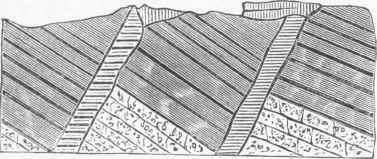
Fig. 12. - Trap Dikes - English Coal Fields.
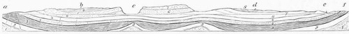
Fig. 18. - Great European Carboniferous Formation.
References: a, Bath; b, London; c, sea; d, Paris; e, Metz; f, Saarbruck. - 1, granitic and gneissic; 2, Silurian and Devonian; 3, carboniferous; 4, Permian; 5, trias, etc.; 6, 7, cretaceous, &c; 8, tertiary, and drift or alluvium.
NAMES OF DISTRICTS. | Tons. | Collieries. | Hands employed. | |
Northumberland | Newcastle field. | 12.500.000 | 183 | 34.000 |
South Durham | 16,800,000 | 102 | 41,100 | |
N. and E. Lancashire (Manchester field)............. | 7,030,000 | 298 | 26,200 | |
West Lancashire and N. Wales.. | 9,000,000 | 189 | 32.300 | |
Yorkshire.. | 11.545.400 | 417 | 36,500 | |
Midland coal districts...... | 8,306,000 | 197 | 28,810 | |
N. Staffordshire, etc (Potteries).. | 6,500,000 | 225 | 21,000 | |
S. Staffordshire, etc. (Dudley coal field)............. | 10,400.000 | 550 | 29.000 | |
Southern coal fields... | 6,500.000 | 195 | 26.000 | |
South Wales... | 9,299,772 | 300 | 29,000 | |
Total England and Wales... | 91.941,172 | |||
East Scotland........ | 8.595,233 | 220 | 27.330 | |
West Scotland......... | 6,339.315 | 201 | 19,654 | |
Ireland........... | 141,470 | |||
Totals.......... | 113,017,195 | 3,142 i | 350,S94 | |
The quantity and value of coal mined in Great Britain for a series of years, and the amount exported, have been:
YEARS. | Tons mined. | Value. | Tons exported. |
1856......... | 66.645,450 | 5.879,779 | |
1860........ | 84.042.698 | £20.010.674 | 7,321,832 |
1864......... | 92.787,873 | 23.107,963 | 8,809.908 |
1867......... | 104.500.480 | 26.125.145 | 10.415,778 |
1868......... | 103,141.157 | 26,785,289 | 10,837,804 |
1860......... | 107.427.557 | 26.856.889 | 10,588,425 |
1870......... | 110.431.102 | 27.607,798 | 11,504.272 |
1871......... | 117.352,023 | 12,549,874 |
Of the total production in 1869, 32,446,606 tons were used in the manufacture of iron. - The developed coal basins of France, as before stated, are numerous, but generally small. They exist around the bases of the great carboniferous and the recent formations. The principal of these are the coal fields of the Loire, including the basins of Rive de Gier and St. Etienne, in the southern extremity of the formation, and the Valenciennes coal field, which is part of the same on its northern outcrops in France and Belgium. The existence of the Belgian coal measures in France was for a long time doubted, but long and persistent efforts, involving an immense expenditure, at length developed this coal beneath the cretaceous rocks on French territory. The total depth of the coal measures in these basins is 4,000 to 5,000 ft., containing 114 coal beds in four series of strata. The upper series contain 49 beds of rich bituminous gas coal; the second has 29 beds of good caking coal; the third has 23 beds of caking coal, not so good; and the fourth has 13 beds of oxygenated or anthra-citic coal. These beds range from 18 in. to 2 ft. 9 in. in thickness, with a few beds 6 ft. thick.
In the St. Etienne coal basin, which is supposed to overlie and include the Rive de Gier basin, the measures are divided into four series, separated by immense barren strata, 600 to 1,200 ft. thick; and the total thickness of the measures is 4,000 to 5,000 ft,, with 206 ft, of coal in 23 beds from 1 to 20 ft, thick. The Bristol (English) coal basin, supposed to be on the western outcrops of the great European carboniferous formation, is likewise divided into four series, much the same as the Belgian measures. The upper series contain seven beds from 12 in. to 2 ft. 4 in. thick; total, 11 ft. of coal. The second series, containing six beds, aggregate 12 ft. of coal; the third series, 12 beds, 35 ft.; and the fourth, 14 beds, with 40 ft. of coal. These series are divided by barren strata from 600 to 3,000 ft. thick, the total thickness of the measures being 8,000 ft. The South Wales anthracite field is an outlying basin, 1,000 sq. m. in extent, of this coal formation. The Saarbrtick field in Germany is the eastern extension of the same; while the Newcastle or more strictly the Scotch fields are the northern, and the basins of the Loire the southern extremities.
In regard to the depth of this great carboniferous formation, Humboldt, in his "Cosmos," observes: "After repeated trials, I have found the lowest coal strata known in the county of Duttweiler, near Bettingen, northeast of Saar-louis, to dip 20,656 ft. under the level of the sea, These Belgian coal measures therefore lie as far below the level of the sea as Chim-borazo rises above it." Much has been said of late about the exhaustion of the European, and particularly of the British coal fields; but the experienced mining engineer knows that the deepest coal even presumed to exist may be mined as safely and as cheaply as that now obtained, because he is aware that the resources at his command are sufficient for the purpose. The prospective difficulty of mining coal at a depth of 10,000 ft. is not now as apparent as 2,000 ft. seemed 50 years ago; and vet coal is now successfully mined, as before shown, at 2,400 ft., in the Rosebridge pit at Wigan. - Machinery for cutting coal has been successfully introduced in the mines of England. The difficulty was not so much in constructing machinery to do the work, as in adapting the plan of mining to machine work.
This has been happily overcome, and in this country S. Harries Daddow has introduced a system which is well adapted to machine mining and ventilation, and has also invented a machine which on this plan will do the work of 50 men. Beds of coal only 18 in. thick are now profitably mined in Belgium, at a depth of 2,000 ft.; while in the Bristol field, which is the counterpart of the Belgian coal beds, less than 18 in. are mined at a cost of 4s. 8ld. per ton. In these small beds machine mining can be used with still more profit, and when worked with compressed air there is scarcely any limit to depth, except that of elevating the coal; and modern appliances will not be balked at 10,000 ft., while 20,000 seems practicable. - The early history and development of coal is very obscure. It appears to have been used by the ancients only to a limited extent. Theophrastus, in his treatise on stones, mentions lithanthrax as used by the smiths of Elis. But the Romans, who excavated several of the ancient aqueducts of France through the coal measures, developing beds of coal, paid no attention to the mineral.
The first notice we find in official records of the development of coal in England, the first country in which the mining of coal became a commercial industry, is the receipt for 12 cart loads of "fossil fuel" by the abbey of Peterborough in 850. But evidences exist to prove that coal was used to a very limited extent by the Britons before the Roman invasion; and the discovery of tools and coal cinders near the stations on the Roman wall, indicates that they must have learned its use from the Britons. The first evidence, however, of regular mining operations is found in the books of the bishop of Durham, by whom in 1180 several leases were granted for mining "pit coal," a term since common among the English miners and writers on coal. The coal of Belgium appears to have been developed about this time, or during the 12th century, near Liege. It is said that a smith named Ilouillos first used coal in the village of Plenevaux, near that place, about this time, and in commemoration of this discovery the French name of coal is houille. Coal was first used in London in 1240; and in 1300 considerable quantities were made use of.
A tax of from Is. to 10s. per chaldron was imposed on coal in England during 400 years, ending in 1803. The first attempt to make pig iron with pit coal appears to have been in 1612, when a patent for this purpose was granted to Simon Sturtevant, but it was unsuccessful. Dudley also obtained patents in 1619 for the same purpose, but also failed, and was imprisoned for debt in consequence. The first successful effort appears to have been made by Mr. Darby of Coalbrook-dale in 1713; and in 1747 cast iron suitable for cannon is said to have been made at this place, both the coal and iron ore used being taken from the same mine. In 1700, 64 furnaces were in blast in the forests of England, producing about 20,000 tons of pig iron annually; in 1788, only 13,000 tons of charcoal iron were made, and 61,300 of pit coal or coke iron; but during 1870, 5,963,515 tons were made with coke and coal. The aggregate steam power of Great Britain in 1860 was 38,635,214 horse power, equal to the productive laboring force of 400,000,000 men, or twice the power of the adult working population of the globe.
Nothing more striking or instructive, in regard to the value of coal when utilized by an industrial community, could be stated than this fact.
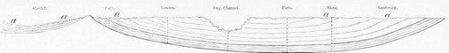
Fig. 14. - Vertical Section on a line drawn from Cardiff, Wales, to Saarbriick.
Continue to:
My Books

